


Photogrammetry in Archaeology: Methods, Use Cases & Limitation
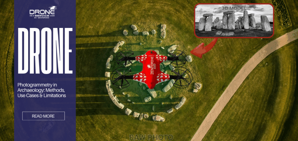
TL;DR
- Photogrammetry is a passive technique of remote sensing that uses redundancy between digital images to extract 3D coordinates from 2D images.
- Archeologists use it for high-resolution site recording, digital twinning of artifacts, and the creation of georeferenced orthomosaics.
- The method is best used when visibility, diffuse lighting, and texture are at their best.
- Photogrammetry cannot penetrate vegetation and cannot simulate transparent, reflective, or monochromatic surfaces.
- LiDAR is also required for terrain mapping, while photogrammetry is preferred to obtain visual textures.
What Is Photogrammetry in Archaeology?
Photogrammetry in archaeology is a digital technique of converting overlapping digital photos to three-dimensional models of sites and artifacts. This modelling conversion allows an accurate 3D representation of landscapes and artifacts for better analysis and preservation of artifacts. The method functions as the main archaeological documentation technique to transform visual data into spatial measurements to be quantitatively analysed.
Archaeological photogrammetry uses a triangulation mathematical method to create three-dimensional spatial models through multiple camera perspectives. Photogrammetry software can determine the exact coordinates of a point in three-dimensional space by detecting the same point from different camera positions. These softwares utilize structures from Motion (SfM), enabling archaeologists to record the site/artifacts without causing damage to these features.
The research process in contemporary times uses photogrammetry archaeology to create visual models that serve as essential scientific tools within modern drone archaeology workflows. These visual models function as accurate research instruments in maintaining the spatial arrangement of artifacts based on their provenience.
This scientific tool functions as an accurate research instrument in maintaining the spatial arrangement of artifacts based on their provenience.
Additionally, the need for stone-by-stone drawing in rescue archaeology becomes critical when development projects restrict the time which researchers spend on manual work. This is crucial in rescue archaeology, where development projects provide a restricted time for researchers to spend manual work on stone-by-stone drawing.
Photogrammetry enables researchers to create metric-space datasets from standard digital photographs. These serve as essential tools for modern archaeological studies and site management activities.
How Photogrammetry Works in Archaeological Documentation
Photogrammetry works by matching pixel groups from different images. It calculates depth and surface coordinates through perspective changes, which create parallax effects. The photogrammetry process begins with image capture to production of georeferenced three-dimensional outputs, which depend on geometric standards and calibration processes.
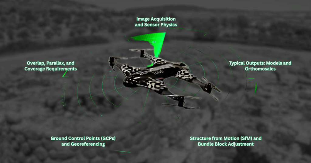
Image Acquisition and Sensor Physics
The process begins with the capture of high-resolution images using a calibrated digital camera. Selecting an appropriate sensor is vital for both unmanned aerial survey operations and terrestrial surveying work. The practitioners typically choose “prime” lenses because these fixed focal length lenses prevent the internal geometric distortions that affect zoom lenses. The main objective is to establish a consistent Ground Sampling Distance (GCP) to show the real-world dimension in a single image.
To achieve the highest data quality, researchers must manually secure the sensor’s Aperture, Shutter Speed, and ISO settings. An aperture of f/8 to f/11 is common to maximize the depth of field. Maximising the depth of field ensures that both the bottom of a trench and its surface are in sharp focus.
Archaeological documentation methods depend on this step for software to create tie-points to connect different sections of a site.
Overlap, Parallax, and Coverage Requirements
Photogrammetry software needs to see all features through three different photos to reconstruct the surface. Though the minimum requirement is three different photos, 5-9 images is recommended for academic accuracy and better results.
- Frontal Overlap: Software requires this setting at 80% to track tie points throughout the camera’s forward motion.
- Side Overlap: Software systems use a setting of 70% to create links between adjacent photo “strips.”
These coverages are usually controlled through automated flight paths in UAV photogrammetry archaeology. Although complex vertical structures need nadir imagery that points straight down and oblique imagery to obtain the required imaging. Without capturing oblique shots, vertical surfaces will appear stretched in the final model output.
Ground Control Points (GCPs) and Georeferencing
Archaeologists use Ground Control Points to transform their relative 3D model into a geospatial document. The site contains these high-contrast targets, which surveyors establish before they start taking photographs.
These targets are used by Survey-grade GNSS/RTK equipment and Total Stations to measure their exact location. The digital model then uses these points to establish its position in Earth’s coordinate system during processing. This process ensures the model matches the actual location of the site, for archaeologists to incorporate it into the geographic information system.
Multi-Return Technology Explained
A single laser pulse in dense vegetation would not simply strike a solid wall; it would strike a lattice of leaves and branches.
The laser beam is physically limited by diameter, and thus, it may break apart when going through the holes in the canopy. These broken reflections are sensitive enough to be reflected by the sensor as discrete data points called returns.
The first return is usually the highest point of the tree canopy and gives information regarding the height of the vegetation.
Intermediate returns can also be shrubbery or lower branches. The most important of the returns to an archaeologist is the last return, as it usually defines the solid ground or terrain modeling on which archaeology is focused.
Why this matters for archaeology: Last-return data is what allows archaeologists to identify subtle features like ancient roads, platforms, and collapsed walls beneath forests.
Structure from Motion (SfM) and Bundle Block Adjustment
The Structure from Motion algorithms, at this point, complete all essential work for the project. The software executes “Bundle Block Adjustment”, which performs mathematical optimization to simultaneously determine three-dimensional scene geographic coordinates.
These coordinates represent the scene geometry, relative movement parameters, and camera optical attributes. The software establishes a sparse point cloud by discovering common “tie points” which are visible, high-contrast pixels. This then allows the creation of a “dense point cloud” which contains millions of individual XYZ coordinates through Multi-View Stereo (MVS) algorithms.
Typical Outputs: Models and Orthomosaics
The final stage involves generating usable data formats:
Orthomosaic: A georeferenced image map commonly used in orthomosaic mapping workflows where every pixel is corrected for lens distortion and topographic relief. These elements function as essential components that enable archaeological GIS systems to work together effectively.
3D Textured Mesh: A geometric model where the original photograph textures are “draped” over the point cloud to provide a photorealistic representation.
Digital Elevation Models (DEM): The system includes both Digital Surface Models (DSM) and Digital Terrain Models (DTM), which require vegetation removal to function properly.
Types of Photogrammetry Used in Archaeology
Archaeology uses three main photogrammetry methods: aerial surveys to study landscapes; terrestrial surveys for architectural structures; and close-range documentation for artifacts. The different types of research need to be addressed through specific methods which exist within the framework of heritage documentation.
Aerial Photogrammetry (UAV-Based)
Aerial archaeology photogrammetry involves using drones to create large-area maps through aerial mapping techniques. Utilising unmanned aerial surveys enables researchers to discover ancient road systems, field boundaries, and earthen mounds hidden from ground view. The method has transformed aerial archaeology, bridging the gap in accessing remains that are hard to access through conventional photography methods.
In addition, it enables researchers to obtain 3D topographic information that remains inaccessible through conventional photography methods. The system enables quick mapping and 3D topographic production of hilltop forts which is usually time-consuming through conventional transit-and-tape approaches.
Terrestrial Photogrammetry
Terrestrial photogrammetry uses ground-based techniques to capture vertical and intricate surface details, including excavation profiles, cave walls, and standing masonry structures. The method serves as a standard practice for archaeological documentation for recording trench wall stratigraphy before it collapses or gets backfilled.
Close-Range Object Documentation
This scale measures complete artifacts including both tiny coins and massive statues. With 3D scanning archaeology, objects are regularly examined by placing these models on turntables for 360-degree photography under standardized lighting conditions. The process creates a “digital twin”, which enables researchers to execute both osteological and lithic studies from a distance.
RTI Photography (and How It Differs)
The specialized technique of RTI photography archaeology (Reflectance Transformation Imaging) enables researchers to record surface details. In photogrammetry archaeology, the photographer moves between multiple locations to capture images for creating a 3D model.
RTI, on the other hand, requires photographers to maintain a fixed position with the light source moving. The resulting RTI images allow users to change the lighting direction to reveal faint inscriptions, petroglyphs, or tool marks. This method serves as the main option to record worn coins and weathered rock art, prioritizing shape details over measurement.
What Archaeologists Use Photogrammetry For
Archaeologists use photogrammetry to create high-precision, 3D records of excavation layers, architectural remains, and artifacts for analysis and long-term preservation. The tool functions as a flexible solution that connects field discovery work with laboratory research activities.
Archaeologists use the method in settlements, graveyards, temples, and underwater explorations to digitally preserve spatial information.
Photogrammetry is usually used for:
Excavation Recording and Stratigraphy
Photogrammetry archaeology most frequently records the daily activities which take place in excavation units. The removal process of strata, which constitutes the first layer of a surface, results in permanent loss of that material. With that, photogrammetry enables “4D archaeology” from 3D models to show the depositional history of the site.
Trench walls, burial pits, floors, and hearths are documented through sequential photogrammetric models. This method is commonly used in rescue excavations in cities, especially in circumstances when there is insufficient time to document findings by hand.
Heritage Conservation and Monitoring
Heritage consultancy services use photogrammetry to monitor structural decay. Conservators can use 3D models from six months ago to identify millimeter-scale changes or erosion rates of a location. Modern heritage documentation uses this proactive method as its primary characteristic for its systematic, precise, and proactive documentation of sites.
Application of photogrammetry in monitoring temples, castles, churches, and historical monuments afflicted by weathering and structural stress. It is also used to digitally conserve heritage sites that are endangered because of various calamities, tourism, and urban development.
Surface Mapping and Landscape Analysis
Detecting human-created earthworks is possible with the integration of remote sensing archaeology data into the research process. These crafted models enable hydrology studies, viewshed analysis, and cost-path analysis by also integrating archaeological GIS systems. By integrating these, it helps researchers deepen their discovery with the advanced details and information it can provide.
These investigators use photogrammetry to map ancient roads, terraces, fortifications, and settlement patterns.
The approach is applicable to the study of human interaction with environments such as those found in the desert, mountains, and coastal regions.
Artifact Documentation
3D scanning archaeology enables digital artifact reconstruction through its advanced imaging capabilities which extend beyond traditional photography. For example, it can digitally reconstruct a fragmented artifact in 3D to discover its volume and shape without further damage.
The field of photogrammetry proves pottery, statues, tools, coins, inscriptions, and skeletal remains with high geometric accuracy. It is often used to virtually reassemble broken objects, which can then be analysed typologically and technologically.
Photogrammetry vs LiDAR in Archaeology
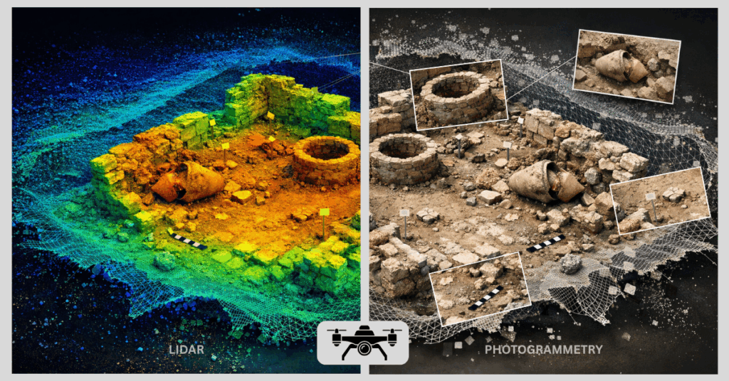
The main difference between the two is that photogrammetry is a passive sensor, while LiDAR is an active sensor. Photogrammetry records only visual lighting while LiDAR sends out a pulse of lighting, which goes through vegetation. Deciding between which to use lies purely in the surroundings of the unmanned aerial survey.
|
Feature |
Photogrammetry |
LiDAR (Light Detection and Ranging) |
|
Vegetation Penetration |
None; records the top of the canopy. |
High; laser pulses reach the ground through leaves. |
|
Visual Quality |
High-resolution, photorealistic color. |
Often lower visual detail; focuses on geometry. |
|
Accuracy |
High on visible, textured surfaces. |
High in all conditions, including shadows. |
|
Cost |
Low; requires a standard camera/drone. |
High; requires specialized laser equipment. |
|
Data Output |
Orthomosaics and textured 3D meshes. |
Digital Terrain Models (DTM) and bare-earth maps. |
Decision Rule:
- If the surface of the ground is exposed, the aerial archeological photogrammetry can be both effective and inexpensive.
- Vegetation obscuring the terrain, however, demands LiDAR archaeology to enable a sight of the bare earth.
Limitations of Photogrammetry in Archaeology
Photogrammetry faces three major restrictions: inability to detect objects through vegetation, requires specific lighting conditions, and inability to model reflective surfaces. The development of archaeological documentation methods requires knowledge about these limitations which must be studied in detail.
Unable to Penetrate Through Vegetation
Aerial archaeology uses photogrammetry to detect only the first surface point that incoming light encounters. The resulting model will show treetops because dense brush or forest cover prevents the detection of underground archaeological features. This limitation makes it inefficient in remote sensing projects that occur in tropical areas and dense forest environments.
In the Amazon, photogrammetry was not effective to reveal buried pre-Columbian earthworks covered by dense forest canopy. In contrast, Maya jungle sites in Guatemala need LiDAR instead, as photogrammetry is not applicable for ground-level data.
Dependent on Lighting and Contrast
It needs constant diffuse illumination because it operates as a passive sensing technology. Photogrammetry incorrectly interprets deep shadows as “geometry” which results in the creation of deep pits and artifacts that appear in the 3D model. Its sensors cannot acquire the essential “texture” information needed for tie-point matching under extremely dim light conditions.
Weather Sensitivity and Environmental Movement
The wind during UAV surveys creates movement of grass and tree branches which interrupts the shooting process. Photogrammetry software creates “noise” and blurring effects in 3D reconstruction because it assumes the environment is static. Additionally, rain and fog reduce the visibility of the recorded images.
The windy conditions at the coastal excavation sites made the UAV captures blurry, necessitating several re-shoots for achieving an accurate 3D model.
Surface Limitations: Specular and Monochromatic Issues
Photogrammetry of archaeological sites becomes extremely challenging when researchers work with objects that possess monochromatic characteristics, transparent qualities, or highly reflective surfaces. It creates a challenge for finding unique, stable pixels to track, leading to a failure of 3D alignment. Terrestrial laser scanning archaeology is efficient in these cases, providing more dependable results than this method.
Photogrammetry undertaken over a wet or foggy archaeological landscape, like wetlands in northern Europe, results in a loss of image clarity. Shiny metal pieces, glazed pottery pieces, or transparent glass pieces may not fit well in photogrammetric models. Even monochromatic limestone walls of ancient temples may leave gaps in the point cloud, leading to alternative documentation methods like RTI.
Photogrammetry, GIS & Long-Term Heritage Documentation
Research workflows use photogrammetry as a data-generation layer which produces 3D models to analyze spatial data through GIS systems. This digital asset functions as a necessary element that supports the complete digital system implementation.
Other remote sensing archaeology datasets such as magnetometry and ground-penetrating radar can be included in georeferencing photogrammetric data. This integration allows researchers to combine all datasets and layer it to analyze in one geographical framework.
Large archaeological sites, such as the Roman Forum, employ photogrammetry techniques with terrestrial scanning to provide detailed archaeological preservation plans (Marín-Buzón et al., 2021).
Archaeological GIS platforms enable researchers to conduct different analysis:
- Volumetric Analysis: Calculating the volume of earth moved for a ditch or mound.
- Viewshed Analysis: Determines what ancient people could see from various locations in their environment.
- Digital Repatriation: Communities receive 3D models which enable them to research their cultural heritage without needing to visit physical locations.
For heritage consultancy services, they use photogrammetry to establish their highest quality spatial archiving standard. It enables heritage documentation since these digital records maintain both metric and visual accuracy of cultural resources. It documents the sites at various stages of degradation and development allowing public access in virtual reality and 3D printing.
Sequential surveys through photogrammetry detect changes over time; they monitor deterioration or any structural issues with the remains (Chiabrando et al., 2018).
When Archaeologists Should (and Should Not) Use Photogrammetry
Archaeologists should use photogrammetry for high-detail surface recording in open environments since it can only capture surface level details. Densely forested areas and reflective objects/surfaces should be avoided as it cannot penetrate vegetation and reflective surfaces.
Best Environments:
- Open-air excavations with clear sightlines and minimal moving vegetation.
- UAV surveys require aerial mapping in both arid and cleared landscapes.
- Indoor artifact photography with controlled, diffuse lighting for 3D scanning archaeology.
Poor-Fit Scenarios:
- Jungle or forest canopy where the ground is obscured.
- Environments with extreme, shifting shadows.
- Sites requiring real-time, instantaneous 3D data (where terrestrial laser scanning archaeology might be faster).
The Future Role of Photogrammetry in Archaeology
The future of photogrammetry will develop through three main technologies: artificial intelligence automation, cloud processing, and multi-spectral sensors revealing underground elements. The core principles of the technology remain unchanged yet its operational capacity is further developing.
The automated UAV photogrammetry archaeology is developing, adopting workflows enabling drones to create automated flight paths bridging data coverage gaps. Photogrammetry is also adopting machine learning technology that now enables automatic object classification within point clouds. This includes the detection of individual stones in collapsed walls and potential artifact identification in orthomosaics.
Although these advancements have improved and assisted archaeology workflows, human archaeologists still remain a primary factor in archaeological documentation methods. Human archaeologists are essential for understanding and analyzing 3D data through their ability to interpret gathered data.
FAQS
What are the applications of photogrammetry in archaeology?
It is the creation of highly accurate, measurable 3D models of the sites and artifacts. This method can record the features that are removed during excavation.
Is photogrammetry considered in academic research?
Yes, archaeological photogrammetry is a well-recognized standard around the globe. Beyond its gold-standard status in archaeology, photogrammetry is a peer-reviewed methodology fundamental to disciplines like geology for monitoring terrain deformation and forensic science for 3D crime scene reconstruction.
How accurate is archaeological photogrammetry?
The accuracy usually reaches centimeter level for sites and sub-millimeter level for artifacts. However, to achieve that, Ground Control Points (GCPs) and high-quality optics are necessary.
Can photogrammetry replace excavation?
No. Photogrammetry only captures the surface. While an important tool of remote sensing archaeology, the technique cannot replace excavation.
Is Photogrammetry Better Than LiDAR?
Both are equally relevant, but neither is better than the other in such a way that one can be said to be superior to the other. Photogrammetry produces better color and visual texture, while the only method to study the terrain covered with dense vegetation is LiDAR archaeology
What environments are not suitable for photogrammetry?
Environments with heavy forest cover, high winds carrying vegetation, or highly shiny, transparent, or featureless surface properties.
Why Drone as a Service (DaaS) Is the Preferred Model for Photogrammetry in Archaeology
Drone as a Service (DaaS) is often preferred for archaeological photogrammetry because accurate data collection requires specialized flight planning, high-overlap image capture, Ground Control Point integration, regulatory compliance, and advanced post-processing workflows such as Structure from Motion and georeferenced model generation. Many archaeological projects are short-term, research-based, or conducted under strict time and budget constraints, making it impractical to maintain in-house UAV equipment, licensed pilots, and processing infrastructure. For projects that require structured deployment and professional oversight, dedicated archaeology drone services provide controlled field operations and standardized data delivery without long-term capital investment.
Read Our Other Blogs

24 February 2026
Photogrammetry in Archaeology: Methods, Use Cases & Limitations
Photogrammetry in Archaeology: Methods, Use Cases & Limitation TL;DR Photogrammetry is a passive technique of remote sensing that uses redundancy...

23 February 2026
The Role of Software in Smarter Drone Power Distribution
The Role of Software in Smarter Drone Power Distribution With the constant development of technology, drones are now classified as...

23 February 2026
Industrial Drone Services for Harsh and Challenging Conditions
Industrial Drone Services for Harsh and Challenging Conditions Industrial drone services deliver a revolutionary solution which enables organizations to handle...
20 February 2026
Thermal Drones: What They’re Used For, How They Work, and When They’re Needed
Thermal Drones: What They’re Used For, How They Work, and When They’re Needed TL;DR Thermal drones are uncrewed or unmanned...
19 February 2026
Drone Surveillance Explained: A Complete Guide to Civilian Drone Monitoring Systems
Drone Surveillance Explained: A Complete Guide to Civilian Drone Monitoring Systems TL;DR Drone surveillance is about using unmanned aerial vehicles....

18 February 2026
Commercial vs Industrial Drone Services in Ireland – Key Differences
Commercial vs Industrial Drone Services in Ireland – Key Differences Executive Summary / TL;DR “Commercial vs industrial drone services serve...