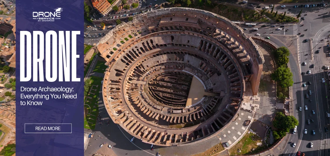
Drone Archaeology Explained: How Archaeologists Use Drones, LiDAR & Aerial Mapping
In 2024, archaeologists used LiDAR-equipped drones to identify two previously undocumented Silk Road settlements beneath the mountainous terrain of Uzbekistan without excavation. What once would have taken years of ground surveys was completed in weeks.
Drone archaeology is the use of UAVs, LiDAR, photogrammetry, thermal imaging, and aerial mapping systems to detect, reconstruct, and monitor archaeological landscapes without physical excavation.
Today, drones carry specialized payloads LiDAR, thermal, and multispectral sensors that see far beyond what the human eye can detect. They capture data in the “mesoscale,” the critical zone between ground-level excavation and high-altitude satellite imagery. The result is a new era of landscape-scale discovery.
This guide covers everything: how drone technology works in archaeology, which sensors to use, how to plan and execute a survey, and real-world examples of what has been found.
What is Aerial Archaeology?
Aerial archaeology is the study and documentation of archaeological sites and landscapes from above. It is one of the oldest forms of remote sensing in the field predating drones by over a century.
The practice began in the early 1900s when pioneers used hot air balloons and early aircraft to photograph ancient sites. The results were remarkable: from above, features invisible at ground level buried walls, filled-in ditches, crop patterns over old foundations suddenly became visible. WWI and WWII aerial reconnaissance photographs inadvertently documented hundreds of European archaeological sites that have since been destroyed.
From aircraft to drones: a shift in scale
For most of the 20th century, aerial archaeology relied on crewed aircraft, which meant high costs, limited flexibility, and coarse image resolution. Unlike satellite imagery, low-altitude drone surveys capture centimeter-level spatial detail, making it possible to identify pottery scatters, wall foundations, and micro-topographic anomalies invisible in lower-resolution datasets.
Low-altitude UAV surveys transformed archaeological mapping by producing centimeter-level terrain models faster and at significantly lower operational costs than aircraft-based surveys. Modern UAVs fly at low altitudes typically between 30 and 120 metres capturing images with a Ground Sampling Distance (GSD) of 1–2 cm per pixel. That is fine enough to identify individual pottery sherds on the surface. They can be deployed in hours, repositioned in minutes, and fitted with a range of sensors depending on the task.
What makes aerial archaeology different from a standard drone survey?
Aerial archaeology is not simply taking photos from the air. It is a systematic, scientific methodology combining:
- Remote sensing — capturing data beyond the visible spectrum (thermal, multispectral, LiDAR)
- Geomatics — precise georeferencing of every data point
- Spatial analysis — interpreting patterns, anomalies, and landscape relationships in GIS software
The goal is not just to document what is visible, but to reveal what is hidden — subsurface structures, buried landscapes, and long-erased human activity.
At drone archaeology services by DaaS, aerial archaeology surveys combine all three disciplines into a single workflow, from flight planning through to final deliverables.
How Drone Technology Is Transforming Archaeological Research
The transformation shifts the discipline from “site-based” to “landscape-based” research. Historically, discovering a site required labor-intensive pedestrian surveys. Teams walked in lines looking for artifacts. Today, a drone maps 50 hectares in one flight. It generates a high-resolution 3D digital twin of the terrain. This efficiency allows archaeologists to answer regional questions. They can map trade routes, agricultural systems, and urbanization patterns.
Researchers in Uzbekistan have been flying drones over the mountains, looking for old cities hidden at high altitudes. Turns out, places like Tugunbulak show the hills weren’t just obstacles they were busy trade centers.
Archaeologists deploy drones to reconstruct terrain, identify subsurface anomalies, and preserve high-resolution digital records without disturbing fragile archaeological layers.
At Drone as a Service (DaaS), professional drone archaeology workflows combine LiDAR, photogrammetry, and multispectral imaging to support large-scale archaeological research and heritage documentation.
Why Is Drone Technology Useful for Archaeologists?
Drones are essential because they are non-invasive. Excavation is destructive; once a site is dug, it is altered forever. Drones allow for “digital excavation.” Sensors strip away vegetation or detect subsurface walls without touching the soil.
This preservation-first approach aligns with modern ethical standards. Additionally, the cost of technology has plummeted. Tasks once requiring crewed aircraft and huge budgets are now done with commercial drones, democratizing access to high-fidelity aerial data for all researchers.
Drone archaeology is not just a technological advancement; it represents a paradigm shift in how archaeologists collect, process, and interpret data. Understanding its history and benefits sets the stage for exploring modern applications and technologies.
Speed and scale that ground teams cannot match
A traditional pedestrian survey teams walking in lines across a site covers roughly 1–2 hectares per day per person. A drone with a photogrammetry payload covers 50–100 hectares in a single flight. For landscape-scale research studying agricultural systems, settlement patterns, or trade routes this is the difference between a research question that takes years and one that takes weeks.
Access to terrain that is impossible or dangerous on foot
Many of the world’s most significant unexcavated sites sit in environments that are simply unsafe or impractical for ground teams. Steep cliff faces in the Andes, dense jungle in Guatemala, flash-flood zones in the Middle East drones reach all of these without putting researchers at risk. This is particularly critical in conflict zones or post-disaster environments, where ground access may be completely blocked.
A permanent, reproducible digital record
Every drone survey produces a georeferenced dataset orthomosaics, point clouds, DEMs that can be re-analysed indefinitely without revisiting the site. If a site is later damaged by development, erosion, or looting, the drone survey becomes its permanent record. This preservation value alone justifies drone surveys at any site considered at risk.
How Are Drones Used in Modern Archaeology?
Key Capabilities That Make Drones Ideal for Surveys
Drones change the way archaeologists look for sites in three critical ways:
- Perspective: From above, low-altitude planes show “shadow marks.” These are small dips in the land that can only be seen when the sun is low, and show features that are buried.
- Resolution: Drones have a Ground Sampling Distance (GSD) of 1–2cm/pixel, while satellites have a GSD of 30cm/pixel. This level of clarity is enough to see individual pieces of pottery on the surface.
- Sensor Versatility: A drone can be used in many types of activities, with the ability to change its payload. To give an example, it can use multispectral sensors to detect moisture under the surface in the afternoon and LiDAR to scan the place in the morning.
Comparing Drone Surveys to Traditional Archaeological Methods
Although conventional practices only offer simple accuracy, drone technology can achieve a substantial gain in efficiency and data saturation.
The table below compares the manual approach utilizing a Total Station to the current aerial surveying.
| Feature | Traditional Method (Total Station) | Drone Survey (UAV / LiDAR) |
|---|---|---|
| Speed & Efficiency | Slow. Mapping a single hectare can require weeks of fieldwork. | Rapid. The same one-hectare area can be mapped in approximately 20 minutes. |
| Data Collection | Point-by-Point. Records individual data points one at a time. | High Density. Collects millions of data points at once. |
| Perspective | Ground-Level. Large-scale geometric patterns are frequently overlooked while wandering in the field. | Aerial View. Reveals route networks and old field boundaries that were previously hidden from view. |
It is essential to note that drones are not capable of avoiding the need for manual inspection. Instead, they transform ground teams to be much more specific. Spots of interest identified using the air allow the archaeologists to drive their manual excavations where they may be required the most.
When Drones Are Most Effective in Archaeological Fieldwork
The three best scenarios in which drones are effective are:
- Vegetated Environments: Drones are handy in highly shaded environments. They rely on LiDAR sensors to accurately map the forest floor and navigate through gaps in the canopy.
- Remote or Hazardous Terrain: Drones are vital in accessing such hazardous regions that are unsafe to humans, such as unsteady cliffs or Andean mountainous peaks.
- Rapid Rescue Archaeology: A drone can document a site immediately in the case of a construction or natural disaster in the area. A good example is the assessment of historic buildings following the Beirut explosion in 2020.
By comparing drone methods to traditional surveys, we can see how UAVs complement and enhance archaeological fieldwork, providing insights that were previously difficult or impossible to obtain.
Types of Drones Used for Archaeology Surveys
Fixed-Wing Drones: Long-Range Mapping and Large-Scale Sites
Fixed-wing drones are like little planes, and they utilize wings instead of rotors to take flight. This design makes them incredibly energy-efficient and aerodynamic.
- Pros: The flights last a long time (60 to 90 minutes) and cover a lot of ground (up to 500 hectares per flight).
- Cons: Can’t hover and needs significant, open areas for “belly landings,” which could break the sensors if the ground is rocky.
- Best For: Mapping of large regions, historical road networks, or farming terraces.
Multirotor Drones: Precision Work and Complex Terrain
The most common type of drone multirotor that is more likely to be used in business is the quadcopter and hexacopter due to their ease of handling and better stability.
- Pros: Vertical Takeoff and Landing (VTOL), hovering, and very maneuverable within narrow spaces.
- Cons: The range of flying (between 20 and 45 minutes) is less because power is continuously consumed to fight gravity.
- Best For: Precise UAV mapping of archaeological sites, tower modelling, and vertical photogrammetry in tight vegetation.
Hybrid VTOL Drones: Combining Range and Stability
The best surveying tools are hybrid VTOLs. They fly off in a helicopter-like manner and roll forward like a plane.
- Pros: It has the safety of a vertical landing and the distance of a fixed-wing plane. It can also haul heavy, high-quality payloads.
- Cons: It costs a lot more than other multirotors.
- Best For: Extensive surveys in the Andes and other rugged terrain where there aren’t many places to land.
Practical Application: When a project calls for detailed structural analysis or specialized equipment, Drone UAV Inspection Services delivers the precision needed to handle complex heritage sites.
Selecting the right drone platform ensures that surveys are efficient, accurate, and tailored to the unique requirements of each archaeological site.
Essential Drone Features for Archaeology
Camera Requirements: Resolution, Sensor Types, and Lenses
A mechanical shutter is critical for photogrammetry. Electronic “rolling” shutters distort movement. This warps map geometry. A 20MP sensor is the standard minimum. 45MP full-frame sensors are preferred for high-fidelity work.
Fixed focal length lenses are mandatory. Zoom lenses shift internal glass. They change calibration parameters mid-flight and ruin measurement accuracy.
GPS and Navigation Systems for Accurate Site Mapping
Consumer GPS is accurate to 2–5 meters. It is insufficient for archaeology. Professional drones use RTK (Real-Time Kinematic) or PPK (Post-Process Kinematic). These systems compare satellite signals with a base station.
They achieve centimeter-level accuracy. PPK is often preferred in remote sites. It does not require a real-time radio link, which terrain usually breaks.
Battery Life and Flight Time Considerations
Archaeological sites are often off-grid. A drone with a 20-minute flight time requires many batteries. Drones with 45+ minutes of endurance reduce logistical burdens. High-altitude environments reduce air density.
This forces motors to spin faster. Batteries drain 20–30% quicker in these conditions. Cold weather causes a voltage sag. Battery warmers are essential for high-latitude work.
Payload Capacity for Specialized Sensors
Small drones carry built-in cameras, but heavy-lift drones are essential for carrying specialized sensors such as LiDAR pucks or magnetometers. These industrial-grade drones must have a stabilized gimbal to reduce vibrations, since even micro-vibrations can blur critical data during aerial mapping, surveying, and inspection missions.
For magnetometry, sensors are suspended on ropes. It prevents electromagnetic interference from the drone’s motors. Heavy-lift platforms are routinely used by Specialized Archaeology Services to install multi-sensor arrays.
Key Sensors and Imaging Technologies
Photogrammetry for Creating 3D Models of Sites
The aerial imaging of archeological sites is done by Photogrammetry, whereby an overlapping RGB image is used to reconstruct 3D geometry. Software is used to determine tie points between images to compute depth.
- Use Case: The recording of excavation layers and the development of photorealistic models of ruins.
- Limitation: It cannot see through vegetation; it models the canopy top, not the ground.
For high-fidelity digital preservation, Professional 3D Scanning Services utilize advanced photogrammetry workflows to create museum-grade models.
Multispectral Imaging for Vegetation and Soil Analysis
Multispectral sensors record the light at narrow bands, such as Green, Red, Red Edge, and Near-Infrared. Researchers use them to calculate such indices as NDVI (Normalized Difference Vegetation Index).
Mechanism: Wall burials limit the growth of the root, and ditch burying of roots traps moisture and thus encourages growth.
Result: In the Near-Infrared spectrum, the stress signals are visible, and the building shapes that are not visible to the naked eye are visible in their geometric forms.
This technology is central to Multispectral Terrain Mapping, allowing researchers to see historical layers beneath modern crops.
LiDAR Sensors for Revealing Hidden Structures Under Foliage
LiDAR is an active sensor that fires laser pulses at the ground, making drone LiDAR archaeology one of the most effective methods for revealing terrain hidden beneath dense vegetation.
- Physics: It uses the “multi-return” principle. One pulse is struck by a leaf, another by a branch, and the last one on the ground.
- Filtering: Archaeologists use filtering (last returns) to remove the forest digitally.
- Discovery: While photogrammetry reconstructs visible surface geometry, LiDAR reveals terrain hidden beneath dense forest canopy, allowing archaeologists to identify buried Maya roads, terraces, and settlement networks and thousands of buildings were revealed under the jungle canopy.
In projects where high-quality topography information is needed in high-density environments, Terrain Elevation Model Services are necessary to produce accurate bare-earth models.
For large and vegetated archaeological sites, professional drone archaeology services are commonly executed through a DaaS model, where specialized equipment and expert-level data processing are provided without requiring in-house investment.
Thermal Imaging for Detecting Subsurface Features
Thermal imaging detects buried archaeological structures by measuring temperature variations caused by differences in soil density, moisture retention, and subsurface stone composition.
- Thermal Inertia: Stone is higher in heat retention than soil.
- Time: The surveys are most effective in the evening or in the morning.
- Detection: As the ground cools at dusk, buried walls stay warm, causing them to “glow” in thermal images.
Sensors and imaging technologies transform raw aerial data into actionable insights, enabling archaeologists to visualize, map, and analyze sites in unprecedented detail.
Preparing for a Drone-Based Archaeological Survey
Understanding Local Drone Regulations and Legal Requirements
The first step in the conduct of an aerial survey is legal compliance. Breaking the law of the airspace may result in either seizure of equipment, fines, or imprisonment.
- Greece: Archaeological sites are designated “Yellow Zones.” Flights are strictly regulated and require explicit permits from the Ephorate of Antiquities.
- Egypt: Drones are technically banned for most civilians. Obtaining a permit is exceptionally difficult and often requires military approval.
- Peru: Drones are restricted imports. You must declare them at customs upon entry. Flights over Machu Picchu are banned without a specific scientific permit.
Site Assessment and Pre-Flight Planning
Effective planning begins before you ever reach the field. Use tools like Google Earth to identify flat, clear takeoff zones and check for visual line of sight (VLOS) obstructions.
- Flight Pathing: Plan paths parallel to the site’s longest edge. Doing so reduces the number of turns that the drone has to make and saves battery life.
- Defining Accuracy: Determine your necessary Ground Sampling Distance (GSD) early. Excavation sites typically require 1cm/pixel accuracy, while broader landscapes may only need 5cm/pixel.
For projects requiring the highest level of data fidelity, Multispectral Terrain Mapping serves as the industry benchmark for achieving rigorous mapping precision and revealing subsurface features.
Selecting the Right Equipment and Backup Gear
Redundancy is critical when working in remote locations. If a single cable breaks in the field, the entire expedition could end.
- Essential Spares: Always carry spare propellers, SD cards, and backup tablets.
- Data Security: Never rely on a single laptop. Bring ruggedized SSDs to back up your data immediately after landing.
Weather Considerations and Environmental Constraints
The weather determines whether your data collection will succeed or not.
- Wind: Wind destabilizes the aircraft and ruins data quality. A majority of the drones are unable to map the area in high wind speeds of more than 10 m/s.
- Cloud cover: Remarkably, cloudy days are most suitable for photogrammetry. Scattered light removes sharp shadows that hinder shapes.
- Thermal Windows: On thermal surveys, fly in crossover (dusk or dawn) windows. Flights at noon erase thermal anomalies due to the sun heating the ground.
Risk Assessment and Flight Safety Protocols
Archaeological sites are delicate and, in most cases, congested. The safety measures safeguard the heritage sites as well as the people.
- Public Safety: Do not fly directly over tourists or excavation crews at work.
- Return to Home (RTH): Select your RTH altitude as high as the highest peak in mountainous terrain. Doing so prevents the drone from hitting the cliffs in case of an automatic return.
Preparation is critical; legal compliance, proper planning, and safety measures ensure successful surveys and protect both personnel and heritage sites.
Conducting the Drone Survey
Creating Flight Paths and Automated Missions
While manual flight is useful for photography, automated flight is essential for consistent data collection. Use mission planning software to set precise grid patterns.
- Overlap Settings: Ensure frontal overlap is 75-80% and side overlap is 60-70% to guarantee the software can stitch images together.
- 3D Modeling: For ruins or vertical structures, use a “Double Grid” (cross-hatch) pattern and tilt the camera to 60 degrees to capture wall details.
Providers of Terrain Elevation Model Services use these precise flight paths to ensure no topographic data is missed during the survey process.
Best Practices for Manual Flight in Archaeological Environments
When manual control is necessary, move slowly. Use “Tripod Mode” (or Cine Mode) to dampen stick sensitivity. It prevents jerky movements that cause motion blur and ensures the drone stays within Visual Line of Sight (VLOS) at all times.
Capturing High-Quality Images and Sensor Data
To ensure professional results, always set the drone camera to Manual Mode rather than Auto.
- Shutter Speed: 1/800s or faster to freeze motion and eliminate blur.
- ISO: 100–400 to minimize image noise (grain).
- Aperture: The f/5.6 to f/8 range is used to obtain a deep depth of field image to ensure that the foreground and background are in focus.
- White Balance: Fixed (e.g., “Sunny”). Auto White Balance should never be used, as it will result in the use of inconsistent colors in the photos.
Ensuring Data Consistency Across Multiple Flights
Sites with a high power consumption might need several battery changes. To keep data consistent:
- Lock Exposure: Do not turn the camera settings between flights.
- Maintain Launch Point: Try not to change takeoff locations even when you can, since it affects relative altitude computing.
- Boundary Overlap: The minimum separation between flight boundaries should be 50 meters to provide the processing software with adequate overlap to allow the distinct chunks to be glued together.
Field Troubleshooting and On-Site Adjustments
This time, you should never leave data on the site.
- Quality Check: Zoom in 100 per cent on the first few pictures to verify that there is no micro-blur. When it is noticed that the drone is having trouble with the wind, slow down the flight speed to keep the drone stable.
- Weak GPS: When in a canyon or dense cover, set the overlap to 90 percent to make up for the possible drift.
Executing the survey efficiently ensures that the collected data is accurate, comprehensive, and ready for post-processing.
Post-Processing and Data Analysis
Organizing and Storing Survey Data
A successful project depends on data hygiene. In its absence, you are likely to lose important files.
- Structure: Create a standardized folder hierarchy: Date > Site > Sensor > Flight Number.
- Separation: Always keep raw GNSS logs in a separate folder from your image files to prevent overwriting or data mismatches during processing.
Processing Imagery with Photogrammetry Software
Industry-standard software like Agisoft Metashape transforms your 2D images into 3D data. A typical workflow involves:
- Import & Filter: Load pictures and filter out any blurred and oblique ones.
- Tilting Photos: Select density of the Sparse Cloud with High accuracy.
- Optimize: Correct lens distortion and GPS drift by optimizing Tag Ground Control Points (GCPs), to bring the model to the real world.
For a deeper dive into this workflow, consult a Drone 3D Scanning Guide to master the nuances of mesh generation and texture mapping.
Creating Orthomosaics, DEMs, and 3D Models
After the first processing is completed, you may produce the final assets:
- Dense Point Cloud: The software computes depth on each pixel, forming millions of points.
- Digital Terrain Model (DTM): Each point is treated as being Ground or Vegetation. The vegetation is stripped off to leave a bare-earth model. It is the core of 3D terrain modeling of archaeology, which distinguishes between ground and vegetation.
- Orthomosaic: An orthomap or map with geometrically adjusted pixels, i.e., pixels where their geographic positions are accurate.
Interpreting LiDAR and Thermal Data for Archaeological Insights
Raw data often hides the most important features.
- LiDAR Analysis: Apply visualization algorithms like Sky-View Factor (SVF). This technique exaggerates slope differences, making eroded earthworks or ancient paths “pop” visually against the flat ground.
- Thermal Analysis: Look for temperature contrasts. Linear anomalies often indicate buried walls (which retain heat) or ditches (which hold moisture and stay cooler).
Integrating Drone Data with GIS Tools
The actual strength of the data contained in the drones is unlocked once it is integrated into a Geographic Information System (GIS).
- Overlay: You can overlay your drone maps on either historical maps or satellite images to find what has changed over time.
- Analysis: Use the least cost path analysis to estimate ancient trade paths using the terrain slope data, which was captured by your drone.
Creating Visualizations for Reports and Presentations
Data must be communicated effectively to secure funding or publish results.
- Digital Media: Develop fly-through videos and interactive Web viewers to attract the masses.
- Physical Models: Use the 3D mesh to create 3D tactile models of the site to be used as learning aids in an educational display or as items in a museum.
Post-processing transforms raw images and sensor data into meaningful models, maps, and analyses that reveal hidden structures and inform research conclusions.
Case Studies: Drone Archaeology in Action
Mapping Ancient Settlements (Uzbekistan)
In 2024, drone LiDAR was used to find two lost cities, Tashbulak and Tugunbulak, in Uzbekistan at high altitudes.
- The Challenge: The locations were buried at 2,000 meters above sea level, which occupied more than 120 hectares.
- The Discovery: The evidence and the extent of fortifications showed that the Silk Road was even better documented than previously thought and has reshaped the history of this trade.
Revealing Hidden Structures in Forested Regions (Guatemala)
The Maya Biosphere Reserve has used the infrastructure of drones to identify anomalies in the large-scale aerial LiDAR.
- The Technique: Drones are capable of flying under the canopy, unlike crewed aircraft, and such places include El Mirador.
- The Result: They produce more dense masses of point clouds that can bring to light tiny looting trenches and ancient causeways that cannot be seen at elevated altitudes.
Using Drones to Document Excavation Progress (Greece)
Drones are used at the Zagora Archaeological Project, where they are flown daily to record open trenches.
- The Innovation: This develops a 4D record (3D space and time).
- The Advantage: To the archaeologist, they can unravel the digitally recorded excavation process, to see the site in its original form at any point in time, which is essential to the post-excavation analysis.
Drones in Understudied or Remote Regions (New Mexico)
The Mimbres Heritage Site was a special case as it had rugged terrain and thick vegetation cover.
- The Solution: Scientists fitted the drones with magnetometers to identify any magnetic changes in the ground.
- The Result: The survey has been effective in identifying a “Great Kiva” and buried room blocks, and then directed focused drilling and saved weeks of blind surveying.
To learn more about the usefulness of these tools in problematic settings, look for more examples of Drone Applications in Remote Environments.
Disaster Recovery Archaeology Supported by Drones (Beirut)
Following the 2020 Beirut explosion, drones were deployed to map the historic districts immediately.
- The Mission: To survey the situation in historic areas without causing harm to any human life.
- The Impact: 3D models were instrumental in enabling engineers to prioritize certain buildings to be shored before the general cleanup was made, and was heritage saved during the catastrophe.
This scenario is similar to the application of Drone Services Across Industries in the fast evaluation of damage during the insurance and construction industries.
Real-world examples demonstrate how drone technology is applied to solve complex archaeological problems and expand our knowledge of ancient sites.
Advantages and Limitations of Drone Archaeology
Key Benefits for Research Efficiency and Accuracy
UAV archeology comes with its own unique benefits compared to conventional field techniques.
- Efficiency: Mapping is not a project involving weeks.
- Precision: The precision of centimeters can be measured without touching it.
- Discovery: Invisible features such as crop marks are made visible with sensors.
- Preservation: Data collection is non-invasive, and the data collection does not harm the site’s integrity.
Common Challenges and How to Overcome Them
Despite the benefits, drone surveys face logistical hurdles.
- Battery Limits: Bring solar generators and calculate watt-hours beforehand.
- Data Volume: LiDAR produces terabytes. Immediately use robust backup protocols.
- Vegetation: Photogrammetry fails in forests. Use LiDAR for canopy penetration.
- Legal Barriers: Partner with local institutions and start permit processes months early.
Ethical and Cultural Considerations in Drone Use
Local populations can experience drones as surveillance.
- Consent: The archaeologists need to seek consent (Free, Prior, and Informed Consent (FPIC) of Indigenous communities.
- Involvement: Engage locals in the process of planning.
- Security: Delete the exact location information in the public reports to avoid looting.
Understanding both strengths and limitations helps archaeologists implement drones effectively and responsibly in diverse environments.
Future Trends in Drone Archaeology
Advances in Autonomous Flight and AI-Assisted Surveying
“Drone-in-a-box” solutions will soon allow autonomous monitoring. Drones will deploy themselves to check for looting or erosion. Swarm technology will eventually map massive sites simultaneously.
Emerging Sensor Technologies
Sensors are shrinking. Hyperspectral cameras and Ground Penetrating Radar (GPR) are becoming drone-compatible. It allows for chemical soil analysis and deep mapping directly from the air.
Integration with Machine Learning for Automated Feature Detection
AI is currently training on drone data. Convolutional Neural Networks (CNNs) can identify burial mounds or kilns automatically. They scan terabytes of LiDAR data in minutes, flagging features for human review.
The Expanding Role of Drones in Community and Public Archaeology
Drones make heritage democratic. Virtual Reality (VR) experiences are created with 3D models. It enables societies to have a glimpse of closed or places that cannot be accessed, leading to a stronger attachment to the past.
The future shows that drones will even be more internalized, as they will be utilised using AI, machine learning, and more sophisticated sensors to transform the way archaeology is conducted.
Conclusion
The Growing Importance of Drones in Archaeological Science
Drone archaeology has evolved into a core archaeological surveying methodology that combines LiDAR, photogrammetry, thermal imaging, GIS analysis, and AI-assisted interpretation to document cultural landscapes at unprecedented scale and precision.
Modern drone surveys allow archaeologists to map hundreds of hectares in a single mission while generating high-resolution orthomosaics, terrain models, and 3D reconstructions detailed enough for excavation planning, landscape analysis, and long-term heritage preservation.
How Drone Technology Will Continue to Shape the Field
Sensors will improve, and AI will automate analysis. The bottleneck will shift from collection to interpretation. Drones enable bigger questions about human history and environmental adaptation.
Final Tips for Getting Started with Drone Archaeology
Start small—master photogrammetry before buying LiDAR. Focus on workflow and accuracy. Respect the site and local communities. Technology supports history, not the other way around.
For professional assistance with advanced aerial surveys, specialized sensors, or data processing, contact us to explore different services.
Frequently Asked Questions
Do archaeologists need special licenses to fly drones?
Yes. Most countries require certification (e.g., FAA Part 107 in the US). Always check host country laws.
What drone is best for archaeological beginners?
The DJI Mavic 3 Enterprise is the current standard. It has a mechanical shutter, RTK module, and is highly portable.
Can drones detect buried structures underground?
Drones cannot directly see underground structures, but they can detect surface indicators such as crop marks, thermal anomalies, and subtle elevation changes. Drone GPR is emerging for direct detection.
Are drone surveys accepted in academic research and publications?
Absolutely. Drone data is now a standard requirement in many peer-reviewed journals.
How do weather conditions impact archaeological drone flights?
Wind ruins stability. Rain damages electronics. High heat drains batteries. Overcast days are actually best for photogrammetry.
Is LiDAR always better than standard photography?
No. LiDAR is best for vegetation penetration. Photogrammetry is better for texture and recording visible ruins.
What software is commonly used for archaeological drone mapping?
Agisoft Metashape is the academic favorite. Pix4Dmapper is also common, while QGIS is used for analysis.
What are the biggest mistakes to avoid when conducting drone surveys?
- Insufficient overlap (creates holes in the model).
- Auto-camera settings (causes inconsistent exposure).
- No data backup in the field.
- Flying without calibration.
Addressing common questions ensures readers understand the practical, technical, and legal aspects of drone archaeology.