Drone Mining Services: Complete Guide to Surveys & Stockpile Measurement
The mining industry exposes workers to numerous hazards daily. One mistake can cause anything from sinkholes and mine flooding to toxic gas leaks and explosions.
Fortunately, technological innovations have given rise to drone mining, which utilizes UAVs to streamline mining operations. Today, drones enhance safety, cost savings, accuracy, and efficiency on their way to becoming the future of the industry.
As AI-driven automation reshapes the global mining industry, the services of drone mining has evolved into a bridge between sustainability, precision, and digital intelligence. In this article, you’ll learn about the difference between traditional surveys and drone surveys in the mining field, its applications, technology, challenges, and best practices.
What is the Difference between Traditional Surveys and Drone Surveys?
It’s a significant contrast to traditional mining surveys. Below is a table that highlights the difference and shows how drone surveys benefit mining. Traditional surveys rely on manual measurements and ground-based tools, which are time-consuming and less precise. In contrast, drone surveys use aerial data collection with high-resolution cameras and LiDAR, providing faster, safer, and more accurate results.
|
Aspect |
Traditional Surveys |
Drone Surveys |
|
Data Collection |
Labor-intensive manual surveying |
Simplified data collection with mining site aerial survey |
|
Safety |
Requires surveyors to be in multi-hazard environments |
Minimizes safety risks via remote monitoring and surveys |
|
Accuracy |
High accuracy but prone to human errors and dependent on the level of expertise |
High accuracy using high-resolution cameras, advanced sensors, and smart AI |
|
Speed |
Takes days or weeks, depending on site size and accessibility |
Can be completed after several minutes to a few hours |
|
Cost |
Pricier long-term costs as labor, equipment, and surveys pile up |
High upfront cost, but better long-term value |
|
Environmental Impact |
More invasive, requiring artificial intervention and disturbance |
Non-invasive, minimizing environmental impact |
|
Applications |
Traditional boundary surveys, geological mapping, and stockpile measurement |
Automates traditional surveys and enables applications like drone mapping, aerial photogrammetry, and digital mining |
Applications of Drones in the Mining Industry
Did you know that drones are incredibly versatile and reliable? They can perform a wide range of tasks, such as mapping, measuring, and assisting in the management of mining sites.
Today, drone mining applications go far beyond traditional mapping. They now integrate predictive modeling, sustainability analytics, and digital twin platforms that make mines more intelligent and efficient.
Mapping & Measurement Orthomosaic Maps
What are Orthomosaic maps?
Orthomosaic maps are highly accurate, georeferenced site maps that reflect real-world measurements. They are made by stitching overlapping aerial images gathered during drone mining surveys.
Orthomosaic maps have many uses, such as
- Set up Geographic Information System (GIS) mining maps for planning and exploration.
- Create basemaps for operations that display the entire site’s geography.
- Determine permit boundaries and ensure compliance with relevant regulations.
- Monitor reclamation and environmental compliance to minimize ecological damage.
- Provide a baseline to allow engineers to monitor and analyze mined ores and site conditions.
Orthomosaic maps come in various formats, which include:
- GeoTIFF files with a defined Coordinate Reference System (CRS) for direct use in GIS software, providing accurate multispectral terrain mapping and analysis
- Web-based “slippy maps” for easy and complete online preview and collaboration
- Metadata such as Ground Control Points (GCPs) or Real-Time Kinematic (RTK) drone corrections in Root Mean Square Error (RMSE) values. This metadata brings accurate reports and crucial information for site monitoring and decision-making.
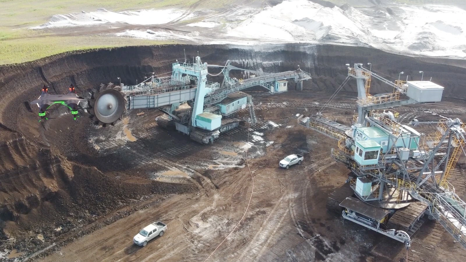
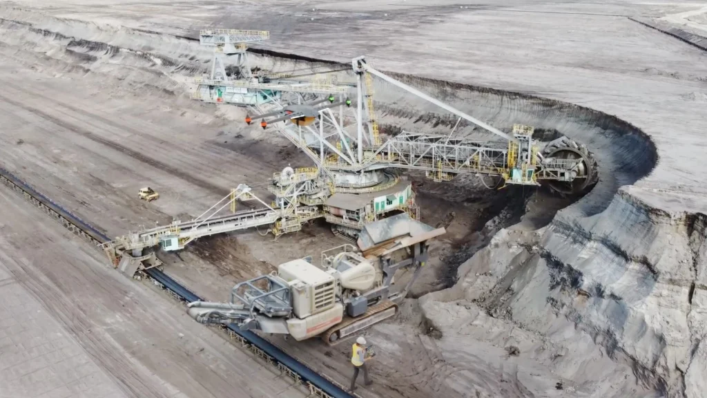
Stockpile Management
What is Stockpile management?
Stockpile management is the process of storing, tracking, and managing extracted materials and minerals into designated stockpiles. It balances operational efficiency, economic goals, and resource utilization during extraction, processing, and distribution.
AI-powered drones now automate stockpile calculations using machine learning-based density prediction, improving accuracy and cutting manual recalculations.
When you manage stockpiles correctly, you reduce environmental impact, enhance worker health and safety, and more accurately account for existing resources. While traditional methods require significant labor and time, drone stockpile measurement improves speed, accuracy, and safety.
Using volumetric analysis, UAVs measure the quantity of materials in a specific space. Let’s see step by step how it works:
- Step 1: Drones fly to stockpiles, capturing imagery using high-resolution cameras, LiDAR, and GPR.
- Step 2: The images are edited and processed according to the project’s needs. For clear visualization, they are used for a Digital Terrain Model (DTM) or elevation model. Meanwhile, a point cloud 3D model offers a more detailed representation.
- Step 3: Specialized software identifies the base plane and top surface of the pile.
- Step 4: The software then calculates the stockpile volume, typically measured in cubic meters.
- Step 5: The calculated volume is converted into tonnage using material density factors.
Additionally, drone stockpile measurement provides several deliverables and applications to streamline mining workflows. These include:
- Change-over-time charts help engineers manage stockpile changes by tracking material movement over time.
- Auditable reports that connect with ERP systems, centralizing communication and collaboration for finance, operations, and compliance teams
- Comma-Separated Value (CSV) outputs, containing volume and tonnage data from surveys that quantify excavated, stockpiled, processed, and distributed materials.
- Inventory reconciliation to verify the amount of material you have matches your initial estimations and spending for transparency and auditing
- Material tracking to ensure the movement and properties of materials, from extraction to processing and distribution
By utilizing drones in stockpile management, you can obtain precise numbers quickly and safely. You not only simplify inventory management but also processes like project monitoring and financial reporting.
Monitoring & Progress Tracking
What is Mine & Quarry Monitoring and How Does it Work?
Mine and quarry monitoring tracks mine developments, such as materials excavated, stockpiles, site conditions, and operational compliance. It uses drones and advanced imaging technologies to capture accurate data, improving planning, reporting, and overall operational efficiency.
Modern UAV dashboards integrate IoT sensors and real-time analytics, enabling continuous monitoring and data-driven decision-making across industrial operations — a capability also highlighted in an MDPI study on UAV- and IoT-based monitoring systems for industrial facilities and digital-twin analytics (MDPI, Sensors Journal).
Circumstances rapidly change as the project progresses, making remote site monitoring essential for gathering real-time data and achieving comprehensive visibility into site conditions. It keeps operations on track for safety, productivity, and compliance while meeting the Service Level Agreement (SLA).
Surveys of Quarry Drones
Mining requires frequent surveys of quarry drones for reliable tracking and support. Typically organized through the following flight schedules:
- Daily Flight Schedules: for active operations and dynamic environments, or when doing short-term planning and significant terrain changes
- Weekly Flight Schedules: for general pit survey updates, excavation checks, volume and blast monitoring, and haul road condition monitoring
- Monthly Flight Schedules: for long-term production management, regular excavation progress monitoring, environmental monitoring, rehabilitation tracking, and reporting
When deciding on flight cadence, consider factors such as on-site rate of change and project needs. You should also consider additional factors, such as compliance requirements, costs, resources, and unexpected developments.
Additionally, you can also align drone surveys with milestones, reporting, and meeting dates to ensure seamless integration.
The Importance of Consistent Mission Parameters
Consistent mission parameters are just as important as regular flight schedules, as they ensure accurate Digital Elevation Models and improve safety and efficiency. Typical mission parameters include Ground Sampling Distance (GSD), flight altitudes, flight path, payload attachments, and lighting windows.
Drone-powered mine and quarry monitoring produces various outputs that support your operations including the following key deliverables:
- Progress time-series orthomosaics: detailed, up-to-date site maps showing changes over time, allowing repeatable time-series insights
- DEM differencing: monitors material movement through cut and fill analysis
- Production Reconciliation Dashboards: tracks the correct alignment of actual volumes with reported output for reporting and audits.
What is Greenfield Exploration?
Greenfield exploration is a significant challenge in the mining industry. Deploying manual surveyors into hard-to-reach spaces and remote areas is both costly and dangerous. However, drones can easily solve this concern.
UAV mining enables remote exploration, simplifying the creation of exploration basemaps—a vital initial step in any mining operation. It brings to life the terrain features, structural patterns, materials, and all the minute details of surveyed areas.
Drones are also equipped with multispectral indices, such as the Normalized Difference Vegetation Index (NDVI), for multispectral mapping to detect vegetation health. It’s used to determine geochemical data by analyzing the differences between plants.
Moreover, drones are equipped with LiDAR technology for mapping inaccessible terrain, providing a complete and accurate 3D model of the survey area.
These two features combine drone data and geochemical sampling to enable target prioritization, saving both budget and resources.
Nevertheless, greenfield explorations require thorough planning. Surveying teams and drone operators must prepare extra batteries, establish reliable communication systems, and develop safety plans for remote operations.
Safety & Risk Management
Pre and Post Blasting Risks
Blasting is one of the most high-risk activities in the mining industry. Fortunately, drones reduce human exposure to hazards while improving the reliability of safety checks. UAVs simplify both pre-blast and post-blast surveys by capturing fast, accurate, and repeatable data.
Pre-blast Survey
Conducted before mining operations begin, a pre-blast survey records the initial conditions of the mining site, nearby structures, and properties. This step is critical for baseline documentation when protecting landowners, residences, and mine operators.
- Clearance Verification. Drones can quickly perform aerial surveys to scan and document the blast zone for compliance purposes. They deliver real-time monitoring, ensuring the blast zone is completely clear of people, vehicles, and equipment.
- Buffer checks. UAVs identify safety buffers, conduct rapid perimeter inspections, and check for intrusions, guaranteeing explosions remain within the intended blast zone.
- Record safe distances. Drones enable fast scanning and analysis of safe distances. They prevent explosions, flying rocks, air pressures, and ground vibrations from affecting people, equipment, and structures.
Post-blast Inspection
Post-blast inspections assess blasted areas to identify potential hazards and prepare mining sites for further use.
- Blast fragmentation analysis. Drones enable automated data collection for measuring and evaluating rock fragments. They deliver objective reports and identify points for optimizing future blast designs.
- Muck distribution. Analyzing muck distribution enhances loading efficiency, safety, and management. Drones provide aerial imaging, done 3D scanning models, software analysis, and documentation on blast performance.
- Bench integrity. Explosions can sometimes cause unintended damage to bench walls. Post-blast inspections verify the site’s integrity to ensure safety and stability before resuming mining operations.
Drone surveys also ensure that mining engineers complete safety checklists and forensic records. They allow operators to conduct blast safety audits, analyze performance, and refine future blast strategies.
Typical deliverables of pre-blast surveys and post-blast inspections include:
- Short videos for quick but complete reviews
- Annotated photos to provide high-resolution imaging of blast zones
- 3D models for site visualization, materials and ore monitoring, and safety management
- Fragmentation histograms showing the size and degree of distribution of rock fragments for technical analysis
Hazard Identification & Slope Stability Monitoring
Worker safety relies heavily on monitoring slope stability and identifying hazards. However, both are time and labor-intensive. Drones have become a necessity in the mining industry for this reason.
Drones combine periodic LiDAR and photogrammetry with geotechnical sensors and Global Navigation Satellite System (GNSS). It captures high-resolution images and 3D data of slopes, allowing you to create Digital Elevation Models (DEM) and detect the smallest ground movements.
Hazard identification and slope monitoring have several practical applications in mining, such as:
- Detect geotechnical hazards early, reducing the risk of slope failures or rockfalls
- Monitor tailings dams for structural movement and compliance with safety standards
- Track erosion or surface changes caused by rainfall, blasting, or heavy equipment activity
- Maintain safer work environments by proactively addressing stability issues
Professional drone monitoring provides actionable outputs, including:
- DEM differencing heatmaps showing where ground movement is occurring
- Displacement logs expressed in mm/day for precise geotechnical monitoring
- Alert thresholds that integrate with mine safety systems for real-time notifications
For best practices, mining operations are advised to set a monitoring cadence based on criticality:
- Daily monitoring for high-risk structures such as active pit slopes or tailings dams
- Weekly or monthly monitoring for less critical areas where gradual changes are expected
Processing Plant & Equipment Inspections
Plants and equipment play a vital role in operational efficiency and profitability, which is why they need regular monitoring. Mining drones can safely inspect processing plants, crushers, conveyors, tanks, and silos — areas that are often hard to reach or hazardous for personnel.
But a question might arise: How do drones accomplish this? Drones are equipped with LiDAR, multispectral sensors, and high-resolution imagery, which enable them to detect potential issues, including equipment wear and tear, blockages, and structural defects.
Drones optimize plant and equipment inspections by:
- Reducing human exposure to dangerous zones
- Detecting equipment wear, blockages, or maintenance needs early
- Generating auditable visual records with annotated photos or short videos
- Streamlining asset tracking and management
Drone mining offers several deliverables, including:
- High-resolution imagery for precise assessment of asset conditions
- Annotated photos detailing defects and other maintenance needs
- Inspection reports with all the details you need, as well as analysis, actionable insights, and points for preventive maintenance
Proper maintenance of processing plants and equipment is key to optimal production and efficiency.
Technological Advancements in Drone Mining Services
Drones have come a long way since their first use for mining purposes. They are now an integral part of the industry thanks to significant advancements throughout the years.
The latest mining technology merges UAVs, LiDAR, AI, and cloud infrastructure into unified geospatial pipelines that automate decision-making.
Group 1 – Data & Modeling Technologies
3D Point Clouds
3D point clouds are digital representations of the actual mine site, showing precise details of its features, including terrain, stockpiles, and infrastructure.
Drone point clouds can be created through either LiDAR scanning or photogrammetry, both of which have distinct applications. Light Detection and Ranging (LiDAR) point clouds are generated using sensors to create 3D models of an environment. It captures data even in dark or vegetation-dense spaces, making it well-suited for scanning through foliage or low-light areas.
Meanwhile, photogrammetry point clouds are built by stitching overlapping aerial images that have been geographically corrected. They are ideal for general survey data, stockpile measurements, and surface modeling for open-pit environments.
Here are the different key aspects of point cloud processing:
- Point density: the number of points per square meter, which affects resolution and accuracy
- Noise filtering: removing stray points caused by reflective surfaces or sensor errors
- Classification: sorting points into different categories, for more accurate modeling
Practical mining use cases for LiDAR and photogrammetry point clouds include:
- Volumetric analysis of stockpiles, enabling precise inventory management
- Cross-section generation for comparing site changes, monitoring slope stability, and designing haul roads
- Pit design and planning, where detailed terrain models guide excavation and infrastructure placement
Digital Terrain Models (DTM)
A Digital Terrain Model (DTM) displays the mine site in 3D. These terrain models do not include buildings, conveyors, or plants, making them crucial for mine planning and environmental protection.
Difference between Digital Terrain Models (DTMs) and Digital Surface Models (DTMs)
The difference between DTMs and Digital Surface Models (DSMs) can help you understand them better:
- A DSM shows the ground model and everything on top of it, like trees, stockpiles, equipment, and infrastructure.
- A DTM removes these features and only renders the actual ground model.
This difference is crucial in mining because decisions about pit design, slope stability, or reclamation depend on knowing the actual terrain, not just temporary obstacles.
Uses of Digital Terrain Models
DTMs have many uses in mining. These include:
- Slope analysis: Bare-earth models help engineers design safer pit walls.
- Pit design: DTMs provide key elevation data for depth excavation, road placement, and drainage.
- Tailings management: DTMs assess storage capacity and monitor changes in elevation.
- Reclamation planning: DTMs serve as the basis for grading plans and landform design when closing and rehabilitating mine sites.
Contour Maps & Cross Sections (L & C)
Contour mapping and cross-sections turn terrain data into actionable insights. Both are derived from Digital Terrain Models (DTMs) created through aerial surveys.
Contour maps and cross-sections serve distinct purposes during the design, planning, monitoring, and reporting stages:
- Contour maps, generated by drawing contour lines, are topographic maps that illustrate surface elevation and terrain. They map out safe routes, evaluate necessary earthworks, and monitor stockpiles.
- Cross sections: Mining survey cross sections are vertical slices through the terrain. They are either along a defined line (L-section) or at intervals across the site (C-sections) and are commonly used in cut-and-fill analysis.
Cross sections serve as a basis for engineers to determine the amount of material that needs to be excavated or filled for the mining design. Cross sections are also widely used in geotechnical reporting.
Here are the outputs typically made from contour mapping and cross-section workflows:
- CSV cut/fill tables for integration into mine planning or ERP systems
- PDF section drawings with labeled elevations and slopes
- Contour maps for regulatory documentation and design updates.
Group 2 – Visualization & Communication
3D Textured Mesh
A 3D textured mesh is a photorealistic 3D model created by combining a photogrammetry mesh with high-resolution textures. They provide a life-like, immersive 3D modelling that’s simpler to understand visually.
While point clouds and DTMs are ideal for analysis, a 3D textured drone mesh is best for presentations. Its realistic visualizations and 3D reviews engage stakeholders and investors, supporting planning approvals.
Example deliverables of 3D textured mesh include:
- .obj and .glTF files that can be used in web-based 3D viewers, where you can interact and explore virtual mine models
- Screenshots for documentation, reports, and presentations
Group 3 – Real-Time Monitoring & Safety
Real-Time Video Monitoring
Drone real-time video monitoring, allowing teams to livestream active operations. It enhances situational awareness and hazard detection during high-risk operations and emergencies.
However, this feature requires strong latency and coverage to ensure the livestream and communication keep running and maintain good quality. You also need to adhere to safe Standard Operating Procedures (SOPs) to ensure that livestream inspections proceed smoothly.
Real-time video monitoring delivers many useful outputs, such as:
- Live-feed links for remote monitoring teams, mining managers, and stakeholders
- Recorded clips that can be stored for reviews, presentations, training, and assessments
- Incident logs complete with time and date stamps for documentation and compliance
You may love to read this: Benefits and Uses of Drone Photography and Videography
What are the Challenges of Drone Mining?
Drones bring massive benefits to the mining industry. But it’s still not a perfect solution. Drone mining also has a few downsides that you should be aware of.
- Data Volume & Processing: Drone mining surveys collect vast amounts of data, which strains ordinary systems. Complex data management, storage, and analysis can impact the accuracy and completeness of drone data. As AI begins to interpret unstructured drone data, the core challenge has shifted from collecting imagery to accurately interpreting high-volume datasets.
- Mitigation: Use cloud processing and data pipelines to automate and streamline the flow of data while also preparing for future scaling
- Weather Limitations: Rain, strong winds, snow, dust, and extreme temperatures can affect drone performance. These factors can make the drone hard to maneuver and result in poor data quality. They can even damage the drone.
- Mitigation: Plan flight windows during ideal weather conditions or use drones with specialized software and hardware for poor conditions.
- Regulatory Variance: Laws and regulations vary depending on location. These make compliance and securing legal documents, such as flight permissions, certifications, and waivers, tricky.
- Mitigation: Seek legal counsel from trusted professional drone service providers to handle all legal details.
- Skill Shortage: Effective drone mining surveys require more than just flying a drone. Operators also need enough experience and adept skills to ensure operational efficiency and success. However, there is a lack of certified pilots and mining survey experts.
- Mitigation: Invest in a partnership with a specialized drone service provider that offers training programs and continuous support.
Solutions & Best Practices – Drone Mining Services
The advantages of drone mining services far outweigh its disadvantages. Its many challenges can be easily addressed by following the best practices of drone mining to ensure safety and efficiency. Additionally, having professional drone services like Drone-as-a-Service (DaaS) at your disposal can go a long way.
Following ISO/IEC drone data standards and using AI-assisted quality checks now ensures better accuracy and compliance in UAV operations.
Actionable Checklist for Reliable Drone Mining Surveys
- RTK/PPK or GCPs: Use Real-Time Kinematic (RTK) or Post-Processed Kinematic (PPK) GNSS corrections, supported with Ground Control Points (GCPs), to minimize positional error (RMSE).
- Standardized Mission Files: Establish consistent and compelling settings, conditions, and procedures to ensure repeatable and scalable operations.
- QA/QC Steps: Run quality checks on your drones before and after flights. You should also conduct QA/QC in drone data to verify its quality and accuracy.
- Metadata Logging: Always capture metadata and contextual information, such as pilot, weather, flight ID, and drone attachment details, to support audits and compliance.
- Cloud + Versioning: Store drone data in cloud-based databases that provide version control, ensuring safe and secure information management.
- Training & certification programs: Train and upskill drone operators for mining-specific purposes and maintain current pilot certifications.
- AI/ML for Auto-Classification: AI-powered mining drones equipped with intelligent machine learning models simplify feature recognition, stockpile segmentation, and automated hazard detection.
Standard Operating Procedures
- Pre- and Post-Flight Checks: Verify drone systems, battery health, and weather conditions in the flight area. Confirm legal boundaries and mission parameters before flights. Inspect for damages and record flight details after.
- Processing QC: Validate control points, check alignment errors, filter noise in point clouds, and document QA/QC logs for traceability. Maintain version control as a safeguard against data loss, as well as for differential backups.
What is the Future of Drones in Mining?
Not only in mining, drones offer services in different industries. For mining, drones are already a strong asset that empowers the mining industry. And with its rapidly evolving technologies, it’s not surprising that UAVs will one day claim their permanent positions in mining.
Here are key trends to watch that may dictate the future of drone mining services.
- BVLOS and Autonomy: Autonomous drones develop alongside more sophisticated AI. Emerging AI-powered drones now self-calibrate sensors mid-flight, reducing data errors and enabling fully autonomous mineral mapping.
These advancements will enable better Beyond Visual Line of Sight (BVLOS) operations, ensuring safer and more efficient surveys.
- Swarm and Fleet Operations: Fleet surveys in drone mining are still complicated today. But it won’t be long until coordinated drone fleets swarm mining areas to conduct simultaneous mine-wide surveys.
- Integration with Digital Twins: Drones will serve as the data backbone for digital twin mining models. They’ll feed real-time 3D updates that link directly into mine planning, geotechnical analysis, and production systems.
- Analytics for Predictive Maintenance: By utilizing AI and predictive modeling, drones can more effectively capture data that anticipates defects and problems. These include ground movements, bench instability, and stockpile issues.
- Sustainability Metrics: Environmental sustainability is a key concern for every technological development. Drones are currently in the right direction as they reduce the carbon footprint of mining activities compared to traditional methods.
Drone Mining Regulatory & Compliance
UAV mining compliance is essential to avoid legal, safety, and financial risks. Here are the different strict regulatory and compliance standards governing drone flights.
- Pilot licensing: Professional drone pilots require commercial licenses, depending on their location and specialization. Ensure legal and proper operator certifications.
- Aviation Permissions: You can’t just carelessly fly drones out in the open in mining sites where you’re likely in proximity to controlled airspace. Secure waivers and permits first, especially for BVLOS, night flights, and high-altitude operations.
- Restricted Zones: Many areas prohibit drone flights, including airports, critical infrastructure, national parks, densely populated areas, and flight-restricted zones.
- Data Privacy: Data from drone mining surveys should be encrypted and protected from data breaches and privacy leaks. As such, mining operators should adhere strictly to data security measures.
- Country-Specific Authorities: Country-specific regulatory bodies, such as the FAA in the USA, CASA in Australia, and EASA in Europe, are subject to different drone laws. Operators must review standards and rules before every project.
- International Guidelines: New frameworks, such as ISO 21384-3:2019 and EASA’s U-Space standards, are defining data governance for global UAV operations.
FAQs
How accurate are drone mining surveys vs traditional methods?
Drone mining survey accuracy is far better than traditional methods. It captures objective and comprehensive data that’s free from human errors and limitations. After all, drone data precision is one of its main selling points.
How long does a drone mining survey take?
The duration of drone mining surveys varies from operation to operation, depending on the site’s difficulty, size, weather conditions, and geographical features. However, with UAV mining efficiency, drone surveys generally take several minutes to a few hours, whereas manual surveys may take days to complete.
Can drones replace topographic surveys?
Drone topographic surveys improve the efficiency, safety, and accuracy of topographical surveys. Objectively speaking, drone mapping is better than traditional surveys. Nevertheless, it can not wholly replace the expertise and experience of human surveyors in analysis and decision-making during mining activities.
Are drone surveys cost-effective for small mines?
Yes. Drone surveys significantly reduce labor costs, speed up data collection, and provide more frequent and detailed data compared to traditional methods. It also increases safety, data accuracy, and ensures mining compliance, leading to high drone mining ROI.
What deliverables should I expect?
There are plenty of beneficial drone mining deliverables. These include orthomosaic maps, 3D point clouds, 3D DTMs and DEMs, audit trails, contour maps, and annotated documentation.
What legal checks are required before flying?
Legal checks are essential to prevent legal, safety, and financial risks. Make sure to adhere to UAV mining regulations, acquire appropriate pilot certifications based on your location, and obtain airspace permissions.
Conclusion
By significantly enhancing accuracy, safety, speed, and promoting cost-effective mining and operational efficiency, drone survey benefits generate worthwhile ROI.
Drone mining is a surefire solution that streamlines the entire mining process from surveying to extraction, processing, and distribution.
As AI and sustainability converge, drone mining services are rapidly evolving into a carbon-efficient, intelligent ecosystem built on digital twins and autonomous systems.