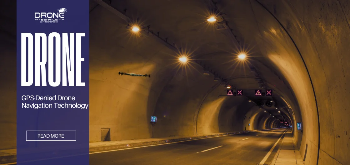
GPS-Denied Drone Navigation Technology
GPS-denied drone technology is redefining how aerial systems operate in environments where satellite signals are weak, restricted, or completely unavailable. From underground mines to dense cities and military zones, these drones use onboard sensors, computer vision, AI, and real-time processing to navigate, map, and fly autonomously without relying on GPS.
Traditional drones depend heavily on satellite positioning for stability, path accuracy, and safe flight. But when GPS signals fail, drones face risks such as collisions, navigation errors, or mission failure. GPS-denied navigation solves this challenge by enabling drones to interpret their surroundings, maintain orientation, and make independent decisions.
As industries demand more reliable, adaptable, and resilient drone operations, GPS-free navigation is becoming essential. Over the coming years, this technology will play a critical role in defense, construction, energy, and emergency response—where precision, safety, and situational awareness matter most.
What Is a GPS-Denied Drone?
A GPS-denied drone is an automated aerial drone designed to fly and navigate effectively in areas with weak GPS signals. It has no dependence on satellites; instead, it uses modern sensors, mapping algorithms, and real-time data processing to determine its location and surroundings.
The groundwork of GPS-denied drone technology consists of modern systems, including LiDAR (Light Detection and Ranging), radar, visual odometry, and inertial measurement units (IMUs).
This enables the drones to view the long-distance areas, detect obstacles, and develop a 3D map of their location without the assistance of the satellite connection. This is why they are needed when undertaking underground investigations, indoors, and GPS GPS-blocked regions.
Difference Between GPS-Based and GPS-Independent Drones
A non-GPS drone relies on onboard sensors, artificial intelligence, and pre-mapped data to perceive its location and intended destination. On the other hand, the GPS drones regulate their position using satellite signals that are effective in open areas and outdoors.
Still, these drones often lose connection and their accuracy in congested spaces or areas with buildings in the skyline, such as tunnels or streets with skyscrapers.
While GPS-based drones are simple to navigate, GPS-denied drones offer much more autonomy and flexibility. They can operate in both open and constrained environments, evade GPS jammer interference, and provide accurate navigation within autonomous drone navigation systems.
Common Areas of Operation of these Drones
GPS-denied drones are designed for areas without GPS signals, such as underground mines, caves, warehouses, industrial plants, dense urban environments, and even military zones with limited signals. Such environments require self-reliant navigation systems that can identify obstacles and changes in real-time.
Regardless of the need to map underground tunnels or inspect the interior of industrial facilities, autonomous drone navigation ensures uniform accuracy and performance.
These drones can analyze surroundings using LiDAR mapping, translate sensor data instantly, and continue operating through the progress in GPS-denied navigation.
Why GPS Signals are Denied or Lost
Although GPS has revolutionized drone navigation, it is not yet a perfect system. It is possible to have a great number of cases when GPS signals become weak, distorted, or unobservable. These issues led to the development of the GPS-denied drone, fashioned to perform operations better than traditional drone systems.
1. Signal blockage in tunnels, caves, and dense urban areas
GPS-denied navigation manages this by using LiDAR, radar, and vision-based sensors to create their own internal maps of the surroundings, ensuring smooth and continuous movement. Satellite signals cannot penetrate solid substances in blocked or restricted areas. This renders the use of conventional drones unable to identify their location or stabilize their flight.
2. GPS jamming or spoofing in military or restricted zones
A GPS-denied drone overcomes these gaps by utilizing GPS-denied drone technology — a combination of intelligent algorithms and onboard sensors that do not rely on external signals. A GPS-denied drone can operate in conflict regions or in safe facilities.
3. Environmental factors like interference or satellite unavailability
Weather, solar storms, or electromagnetic interference from heavy equipment can damage GPS accuracy. Meanwhile, drones equipped with autonomous navigation systems are not affected in remote areas with poor satellite signals. They rely on real-time sensor fusion and onboard computing to maintain orientation, enabling advanced applications such as how drones are used in archaeology, even in challenging environments.
How Can Drones Fly Without GPS?
Most people believe it is not possible to make a drone fly without GPS. Yet, the GPS-denied drones accomplish this through a set of sensors, algorithms, and computational intelligence.
The spatial awareness with sensors
The drone sensors work together to build 3D representations of their environment, operating as the basis for autonomous drone navigation. Modern GPS-denied drone technology employs LiDAR, radar, and IMUs (Inertial Measurement Units) to detect distances, objects, and calculate motion.
SLAM (Simultaneous Localization and Mapping)
SLAM is an essential algorithmic operation that enables a drone to map a new territory and, simultaneously, determine its location within the mapped space. This strategy is a pillar of GPS-denied navigation, enabling precise and accurate movement in real-time, even without the use of satellites.
AI-driven algorithms for environment understanding
AI-based decision-making makes autonomous drone navigation is effective. Through modern artificial intelligence and pattern recognition, non-GPS drones interpret visual and spatial information to identify obstacles, locate open paths, and adjust their flight directions.
Key Technologies Behind GPS-Denied Navigation
Several innovations make GPS-denied navigation possible and accurate:
- Visual odometry & computer vision: Detect and analyze imagery to estimate movement and create visual maps.
- LiDAR & radar systems: Detect and measure distances, shapes, and barriers with millimeter-level precision.
- Sensor fusion & onboard AI processors: Analyzes multiple data inputs to maintain location accuracy.
- Inertial Measurement Units (IMUs): Computes acceleration, incline, and rotation for consistent stabilization.
- Ultrasonic & infrared sensors: conserves close-range barrier avoidance in tight and indoor spaces.
- Edge computing modules: secure data locally, ensuring real-time analysis and instant adjustments.
When Is a GPS-Denied Drone Necessary?
The situations in which standard drones fail are numerous, including the absence of satellite signals or their interference with other signals. In this matter, the GPS-denied drone becomes important.
GPS-restricted zones or restricted zones
The signal reception is frequently low or nonexistent in industrial plants, tunnels, and underground networks. In this context, GPS-denied navigation assures reliable flight performance by using LiDAR mapping and sensor-based tracking to navigate safely without external coordinates.
Rescue and military activities
During defense missions or emergency operations, the dependability of navigation may be the key to success or failure. GPS-denied drone technology provides a major advantage here it cannot be jammed or spoofed. When GPS interference is prevalent, soldiers and first responders rely on these drones to support critical military and rescue operations.
In-house and underground inspections
For industries such as mining or energy production that rely on precise data, non-GPS drones are used for visual inspections in areas like pipelines, power plants, or mines. These systems gather vital information by utilizing self-driving drones, minimizing human risk, and maintaining a continuous work process in enclosed areas.
Industries That Use GPS-Denied Drones
The effective applications of GPS-denied drone technology are rapidly growing across both public and private sectors. It is very flexible thus making it a necessity in almost every field where accuracy and reliability are needed.
- Defense and Security: Military forces utilize instant intelligence, which cannot be derived with by any signal disruptions and use GPS-denied drones in areas with no GPS signal for surveillance.
- Energy, Mining, and Construction: Drones may work in the locations with no GPS signal, like underground or narrow areas. With the use of GPS-denied navigation, they identify visual and spatial data, improve inspection accuracy and worker safety.
- Logistics and Manufacturing: Autonomous drone navigation is utilized in large warehouses and production plants to automate inventory auditing, goods movement, and equipment inspection. Therefore, non-GPS drones are the ideal solution.
- Agriculture: Farmers in remote areas can utilize GPS-denied drone technology to monitor crop health, irrigation systems, and their farm animals, even when GPS signals are limited.
- Telecommunications: These drones survey base stations, fiber-optic tunnels, and tower interiors, places that are usually inaccessible to human operators.
- Emergency Services: Rescue teams rely on GPS-denied drones to locate victims and assess structural damage in affected areas where communication networks are down.
Use Cases for GPS-Denied Drones
GPS-denied drone technology is highly adaptable and used in many real-world situations.
Here are the use cases:
- It is used for mining, sewer inspections, and exploring underground infrastructure.
- Drones can monitor pipelines and power lines in areas where GPS signals are weak or unavailable.
- They help with facility management and indoor surveys at construction sites.
- The military uses them for reconnaissance in areas where GPS is jammed or restricted.
- They are also used to inspect industrial factories and plants.
- Other uses include geological mapping, civil engineering projects, and mapping tunnels or caves.
- Rescue teams use these drones in places where GPS signals are weak.
All these examples demonstrate the effectiveness of GPS-denied navigation for missions that regular drones cannot handle. With autonomous navigation, operators can trust their drones to avoid obstacles and complete tasks even when GPS is unavailable.
Benefits of Using a GPS-Denied Drone
The GPS-denied drone has become one of the most developed innovations in modern aerial systems. The fact that it can navigate without the assistance of satellites indicates that it has extra benefits in various regions.
- Reliable navigation in complex environments: Drones are stable and precise even in locations where GPS signals are blocked.
- Improved autonomy and signal resilience: By harnessing internal sensors, AI algorithms, and processing power, autonomous drone navigation is ensured to continue during total GPS outages.
- Operational versatility: The GPS-denied drone can operate in both public and private areas, demonstrating its value in industrial surveillance, military operations, and rescue missions.
- Safety and efficiency: Non-GPS drones reduce the need for human intervention and can collect data for investigations, even in hazardous areas.
Innovations and Future Trends in GPS-Denied Drone Technology
The next generation of GPS-denied drone technology is rapidly developing towards greater intelligence, collaboration, and independence.
- AI-based flight learning: Future drones will continually learn, enhance mapping capabilities, and operate efficiently in the long run.
- Swarm navigation systems: Non-GPS drones will cooperate on specific tasks, exchanging real-time information to accomplish goals such as rescue missions.
- Edge computing integration: Drones will be able to make real-time decisions without using the external servers because the process of data processing and analysis will be performed locally.
GPS-Denied Drones vs. GPS-Based Drones
GPS-based and GPS-denied drones are two fundamentally different ways to navigate in the Unmanned Aerial Vehicles sector.The former uses satellite signals and the second one uses onboard control and a very advanced degree of autonomy in order to manage safely those places having blocked signals or in sensitive environments.
| Feature | GPS-Based Drone | GPS-Denied Drone |
|---|---|---|
| Navigation Source | Satellite signals | Sensors, LiDAR, computer vision, IMUs |
| Operational Zone | Outdoor areas | Indoor, underground, or jammed environments |
| Signal Dependence | High | None |
| Autonomy Level | Limited | Advanced |
| Maintenance Needs | Low | Higher (requires sensor calibration) |
| Reliability in GPS Loss | Fails | Continues operation |
While GPS-based drones are great for outdoor tasks, the GPS-denied drone surpasses them in flexibility, intelligence, and operational range.
Safety and Regulatory Considerations
Operating drones involves a significant amount of responsibility regarding safety and Regulatory Considerations, which will provide the required framework of accountability for operators, obligatory safety features, and morally responsible development of an emerging technology.
Operator Responsibilities
Drone operators are responsible for following all aerial traffic laws, avoiding human-operated aircraft (such as planes and helicopters), and using proper communication systems. The operators should also make sure that they do not disrupt aircraft that are operated by people, such as planes and helicopters, especially in common or busy airspace.
To prevent accidents and to have the smooth and coordinated operations, there are necessary tasks like having stable communication systems, local airspace classification awareness, and pre-flight safety inspection in order to avoid accidents.
Built-in Safety
The drone should be designed with safety functions, such as its ability to avoid technical failures and accidents, a risk management strategy, and a recovery program on how to safely land the drone in case of a loss of signal.
The current drones should be developed to be safe in both software and hardware to reduce risks. Obstacle avoidance systems can be present, automated fail-safes can be set to prevent malfunctions, and the algorithms of preventing crashes can be the state of art.
Ethics for New Technology
There is a need to balance the development of new drone technology and its responsible usage. In the way of ensuring security and securing the safety of the environment. The developers and operators ought to know about the overall effects of drone usage, such as how they can guarantee the safety of data delivery and avoid the damage to wildlife and the natural environment.
Being an industry that is concerned with ethical conduct, it is possible to establish trust, assist in the continuation of the growth, and advance the safe implementation of drones into the society.
Conclusion
GPS-denied drone technology represents a major step forward in autonomous flight, enabling drones to operate accurately and safely without satellite signals. By leveraging LiDAR, radar, SLAM, AI-driven decision-making, and advanced sensor fusion, these systems overcome the limitations of traditional GPS-based drones and unlock new capabilities across defense, mining, construction, energy, logistics, and emergency response.
As industries demand more reliable and adaptable aerial intelligence, GPS-denied drones deliver a critical advantage in confined, underground, or signal-blocked environments. With continued advancements in AI and onboard computing, these drones will play an essential role in improving safety, efficiency, and mission success in the years ahead.
Frequently Asked Questions
Can drones really fly without GPS?
Yes. The alternative methods that may be employed to ensure that the drone operates without GPS are the use of visual sensors, LiDAR, inertial measurement units (IMUs) and onboard mapping.
What sensors work best for shallow-water mapping?
The most suitable techniques for mapping in shallow water are multibeam sonar, LiDAR bathymetry, and photogrammetry (utilizing high-resolution cameras), as they are capable of recording depth and capturing every detail on the waterbed at the surface.
How do GPS-denied drones navigate accurately?
There is a mixture of SLAM (Simultaneous Localization and Mapping), LiDAR, cameras, IMUs, and machine learning algorithms that help the GPS-denied drone navigate. These devices assist the drone in creating a live map of its immediate surroundings and can also monitor the drone’s exact position.
Where are GPS-denied drones most useful?
They are best applied in areas where GPS signals are weak, blocked, or deliberately jammed, such as indoor facilities, underground mines, thick forests, urban canyons, military operations, and disaster areas.
What sensors are used in GPS-denied drones?
LiDAR, standard cameras, thermal cameras, motion sensors, sound sensors, depth sensors, and radar are integrated to maintain stable navigation and enable reliable obstacle detection.
Are GPS-denied drones better than GPS-based drones?
Not always. GPS-denied drones are superior in closed or GPS-blocked zones, whereas GPS-based drones are superior for outdoor missions, long-range missions, high-altitude operations, or high-range operations. It depends on the mission requirements to select the best one.
How accurate is navigation in GPS-denied environments?
Technology-dependent, but the state-of-the-art GPS-denied systems are able to reach centimeter-to-decimeter-scale accuracy through LiDAR and SLAM, particularly in structured (rich in visual features) environments.
What industries benefit most from GPS-denied systems?
The industries that use GPS-denied drones are Mining (surface mapping and examination), Search-and-rescue (missions, investigations, and public safety), Construction (indoor site mapping), Oil and gas (inspections, pipeline and facility), Forestry & agriculture (dense canopy operations), and logistics/ warehousing (indoor automation)
Will GPS-denied technology replace traditional GPS in the future?
Not entirely. Large-scale outdoor navigation will not be possible without GPS. Nevertheless, GPS-denied technology will be further developed in the future as an auxiliary system, providing a reliable means of navigation in areas where GPS access is not possible or is subject to interference.