Is It Legal to Fly a Drone Over Private Property?
The drone revolution is upon us, but the fight for airspace may be occurring over our backyards. With hobbyist and professional drone ownership soaring, a critical conflict has emerged at the intersection of federal air freedom and private property rights. The key question is: where does the “public” airspace begin and your “private property” end? This low-altitude boundaries vary considerably across the globe and are now subject to intense legal scrutiny.
In this article we will discuss about drones over private property law. It is vital to understand the new drone privacy laws so you do not end up being charged with trespassing or surveillance.
Navigating the Sky: Understanding Airspace Ownership
Drone technology is challenging the ownership rights of property owners versus the freedom of the airspace. As drones become prevalent, the critical legal question is not whether a drone can fly, but rather where.
For compliance, it is important to understand airspace ownership rights:
Navigable Airspace
Air space at higher altitudes is regulated by agencies such as the FAA (U.S.), CAA (U.K.), and EASA (E.U.), primarily for the purpose of safe flight.
The “Immediate Reaches” Doctrine
The US Supreme Court determined that property owners do in fact retain exclusive rights to the air above their property in limited space called the “vertical curtilage.”
The Altitude Distinction:
- High Altitude (Example 350 ft AGL): Typically a legal overflight under federal rules, posing minimal risk.
- Low Altitude (Example 50 ft AGL): Located in the “immediate reaches,” this risks committing aerial trespass or nuisance, as seen in cases where courts affirmed ownership rights around 100 feet AGL.
Compliance Check: National Drone Laws and Private Land
Drone operations are regulated by aviation authorities that identify where it is permissible to fly for example:
National Rules
Authorities such as the FAA (Part 107, U.S.) and the UK CAA/ EU EASA have the authority to establish the required rules for flying by both commercial and recreational pilots, which includes the altitude ceilings usually 400 ft. AGL.
Permissible Overflight
Generally, it is legal to fly a drone over private land. As long as the drone remains above the federally/nationally classified navigable airspace and complies with any safety regulations that apply. Example is maintaining Visual Line of Sight (VLOS).
The Legal Trap
However, flying low or intrusively especially lower than the 400-foot ceiling and within the landowner’s “immediate reaches,” can change legal overflight into a high-risk operation.
Consequences
Flying without authority in a reckless or intrusive manner over private land may result in regulatory fines, warnings, and civil actionable trespass or nuisance.
Privacy Rights of Property Owners
Drone flight can turn from a permissible overflight to illegal surveillance thus, private land owners must understand their rights:
Invasion of Privacy
Taking pictures of private, hidden spaces such as fenced-in backyards/pools or indoors through windows, you are violating privacy, even if the flight adhered to FAA safety regulations.
Consent is Key
Property owner rights often extend to the low-altitude airspace immediately above their land, which is why drone operators must obtain consent before flying low.
Global Data Protection
In Europe, the GDPR applies to drone operators capturing any identifiable personal data. It holds operators responsible for safely processing data, and justifying the purpose for processing.
Legal Precedent
Courts consistently side with landowners. Especially when drone flights are deemed intrusive, persistent, or intended to spy, treating it as an actionable trespass or harassment.
Trespassing vs. Legal Overflight: The Intent Test
A person physically entering your property without permission is clearly trespassing. The invasion of air space via drone is somewhat murky:
| Legal Overflight | Illegal Overflight / Trespassing |
|---|---|
| Drone flies at a higher altitude (generally closer to or above 400 feet). | Drone flies low within the landowner’s immediate airspace. |
| Brief, non-intrusive flight across private property. | Prolonged hovering or lingering over private areas. |
| Purpose is legitimate, such as powerline or infrastructure inspection. | Purpose involves surveillance, spying, or harassment. |
| No substantial interference with property use or enjoyment. | Causes unreasonable interference or disturbance. |
| Generally compliant with aviation and safety regulations. | May result in trespass, nuisance, or stalking claims. |
The Local Patchwork: Checking No-Fly Zones
While the federal government set the 400-foot ceiling, specific state and city ordinances govern low-altitude behavior and airspace access:
- Regional Differences: Drone laws vary widely across the United States. For example, some states and many countries prohibit flying drones near critical infrastructure such as power plants and refineries that tend to be located in rural areas.
- Strict Local Enforcement: Cities such as London, and many areas in California, will have strong enforcement against drone use in “no-fly zones”. Usually, it is for public safety value and near airports and sensitive private property.
- Restricted Airspace: no-fly zones may also include areas such as National and State Parks where launching or landing is prohibited altogether.
Low-Altitude Risk: What Happens If You Fly Without Consent
Flying a drone in the “immediate reaches” of private property can expose the operator to significant legal and financial liabilities:
Operator Liability
Unauthorized operation of a drone at low altitudes can expose the operator to a claim of civil trespass or invasion of privacy. This results to potential penalties, including fines or damages. This may also result in FAA warnings and regulatory fines as high as $25,000.
Owner Remedies (Legal)
Property owners must report violations by documenting the incident through photo/video evidence of the drone and time. Then contact local police, who can enforce state-level privacy and trespass laws.
The Retaliation Trap
Owners should understand that physical retaliation can expose them to unlawful circumstances. Shooting any aircraft, including a drone, is a federal felony.
The Solution
Operators and owners should work to the root cause of the issue and try to communicate respectfully with one another. It is always better to accomplish a resolution through thoughtful dialogue than use of court or other forms of retaliation.
Drone Surveillance and Recording Laws
Generally, filming publicly is allowed, but filming private property requires a higher level of scrutiny to avoid violatin privacy laws:
- Private vs. Public: It is legal to film a private house from a public road. However, it is illegal to film or hover over a pool or window in the owner’s backyard where there is an expectation of privacy.
- The Consent Requirement: Taking images of private, secluded areas without the owner’s permission will likely turn a legal flight into illegal surveillance.
- Anti-Peeping Laws: Many U.S states and countries, have specific anti- drone surveillance laws. California’s and Florida’s laws make it illegal to film private activity where there is an expectation of privacy. This exposes the operator to civil liability.
- Global Data Protection: The GDPR in Europe is triggered if footage captures identifiable personal data. In that case, the operator would need a legal authority to gather that identifiable personal data.
The Good Neighbor Policy: Ethical Drone Flying
Adhering to drone over private property law through ethical operation is crucial for preserving neighborly trust and preventing legal challenges in your community.
Respect the Sanctuary
Always maintain safe distances and consciously avoid sensitive areas where there is an expectation of privacy. Ethical standards suggest to take reasonable measures to minimize operations over private property without owner or occupant consent.
Voluntary Standards
It’s important to exceed regulatory minimums. While there are other voluntary organizations you may want to join. The AMA (Academy of Model Aeronautics) and Dronecode set standards for best practices to ensure safe and respectful operating practices.
Proactive Notification
The most effective defense against confrontation is transparency. You should notify neighbors or property owners of the general time and purpose of your flight. Particularly if your operation may disrupt their immediate airspace for a short period of time.
The Golden Rule
If you wouldn’t stand on the ground and look over a fence or peer into a window, don’t use a drone to achieve the same result. Responsible operators build trust, ensuring the continued freedom to fly in this thrilling new age of aviation.
Secure Your Flight: Getting Consent Over Private Land
The drone over private property law states that consent is the best protection from expensive trespass and privacy claims:
The consent process
Always obtain written consent from the property owner before flying in their ‘immediate reaches’ or using their property for takeoff or landing. A brief explanation the purpose, targeted height, and estimated length of time for the flight will suffice.
Avoiding accidental trespass
Utilize applications such as the FAA’s B4UFLY application and GPS geofencing to properly identify the property boundaries and to designate safe flight zones to avoid drone trespassing.
Commercial waivers
Professional work with a drone will typically require you to obtain a formal agreement. Commercial operators should obtain airspace easements or formal waivers and ensure that they have sufficient liability coverage.
Crash Protection: Why Drone Insurance is Non-Negotiable
Violating drone airspace ownership rights carries financial consequences that can far exceed the cost of an insurance premium, potentially resulting in extensive liability after an accident.
- Strict Liability Risk: If your drone malfunctions and causes injury or property damage such as breaking a window, you are subject to strict liability for that financial obligation, as the operator.
- Liability Insurance Coverage: Dedicated drone insurance can provide valuable Third-Party Liability coverage for property damage, and bodily injury. Property Owner Privacy claims, which many homeowners policies specifically exclude.
- The Intent Exclusion: Be warned, most insurance policies also have exclusions for illegal acts. If your drone crashes while flying in violation of an FAA regulation or a state/local anti-trespass law, your insurer may very well deny your claim.
- Pilot Professionalism: For commercial claims, actually having proper certification such as a FAA Part 107 license will almost always validate regulatory compliance. This is important to get your claim and demonstrate pilot professionalism to the insurer, and your client.
The Next Horizon: Accountability and the Future of Airspace
The scenario is changing quickly with regard to the regulatory environment on safety and privacy in low altitude airspace to keep the sky safe for all users.
| Technology / Regulation | Purpose & Impact |
|---|---|
| Remote ID (Digital License Plates) | Broadcasts a drone’s identity and location, increasing accountability and enabling law enforcement to track and address illegal or unsafe flights. |
| Geofencing | Prevents drones from entering restricted or sensitive airspace by using built-in software controls. |
| UTM & LAANC | Manages low-altitude and urban drone traffic, allowing authorized access while improving safety and compliance. |
| AI-Based Monitoring & Enforcement | Uses artificial intelligence and advanced tracking to monitor drone activity, enforce regulations, and support future vertical airspace zoning. |
| Vertical Zoning (Future) | Designates specific altitude ranges (e.g., 200–400 feet AGL) for commercial transit, protecting ground-level privacy while enabling aerial commerce. |
The path forward emphasizes technology and transparency, ensuring the drone revolution is responsible and respects the privacy of your home.
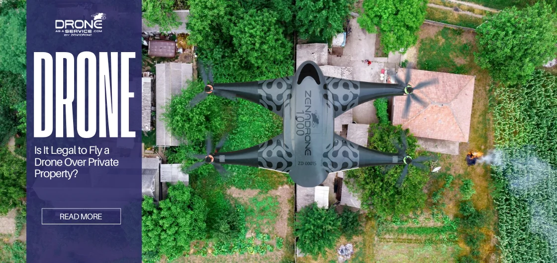
Debunking Drone Overflight Myths
Most of the misunderstandings regarding drone operation have the potential to generate unintended legal issues. Responsible flying requires an understanding of where aviation law ends and where property rights begin.
Myth #1: “If it is in the air, it is public.”
Truth: The law, including aviation law, protects a landowner’s “immediate reaches” (the airspace from 0-200 ft AGL). A brief flight at altitude may be permissible, but hovering lower is aerial trespass, regardless of FAA compliance.
Myth #2: “I can capture anything that I can see from above.”
Truth: Visibility does not grant permission. State law prohibits the use of drones to record areas in which there is a reasonable expectation of privacy.
Myth #3: “Drones under 250g are exempt from state privacy laws.”
Truth: Regardless of physical size and weight, all drones (including those under 250g) are aircraft and are subject to local laws regarding trespass and nuisance.
Myth #4: “In rural areas, I have no restrictions.”
Truth: False! Rural land is contained in large areas of critical infrastructure and rural areas are often subject to state laws prohibiting any type of activity that would disturb wildlife or agriculture.
Compliance and Community: The Final Frontier of Flight
The rise of the drone era has created an exciting, yet complicated, legal landscape defined by the competing rights of airspace freedom and privacy. To fly legally and ethically, operators must abandon the assumption that “if it’s in the air, it’s public” and understand that the “immediate reaches” over private property is legally protected.
Compliance requires obtaining affirmative consent for low-altitude flights and vigilantly monitoring local anti-surveillance laws. The legal future of this technology and its adoption in our communities depend on responsible use, transparency, and communication. It is crucial to keep abreast of new Remote ID and vertical zoning legislation as the law shifts to the pace of innovation.
This transition is underpinned by technological evolution. The success of Drone-as-a-Service (DaaS) features like autonomous delivery relies on evolving Inertial Measurement Unit (IMU) advancements to ensure the precise navigation and stable flight necessary to adhere strictly to these complex legal and privacy boundaries.
Frequently Asked Questions
Is it trespassing if a drone flies over my backyard?
Yes, a drone may be considered to be trespassing aerially or to be causing a nuisance if it flies too low (generally below 100-200 feet AGL) and it significantly impacts the use of your property according to state law.
Can I shoot a drone that is flying over my property?
No, shooting a drone is a federal felony, damaging an aircraft. The right thing to do is to document the drone incident and report it to local law enforcement.
How low can drones fly legally over private land?
The FAA maximum is 400 feet AGL. However, a lot of courts have held that the airspace below 100-200 feet AGL is considered to belong to the proprietor as part of their “immediate reaches.” This is where you might find a risk of trespass.
Do I need to get permission to film someone’s house with a drone?
Yes, if the drone is filming areas in the expectation of privacy (for example, backyards or through windows) you need to get consent from the person who owns the house to comply with state anti-surveillance laws.
What should I do if I believe a drone invaded my privacy?
Document the incident (date, time, photos) and report it to your local police department. You may also be able to pursue civil legal action for invasion of privacy or nuisance.
Read Our Other Blogs
17 December 2025
What Is Return-to-Home (RTH) on Drones?
What Is Return-to-Home (RTH) on Drones? The worst thing that could happen is losing an expensive drone while on a...
17 December 2025
Is It Legal to Fly a Drone Over Private Property?
Is It Legal to Fly a Drone Over Private Property? The drone revolution is upon us, but the fight for...
12 December 2025
Top 7 Drone Concrete Inspection Mistakes to Avoid
Drone Range Explained: A Complete Flight Distance Guide Drone concrete inspection uses UAVs to collect accurate data for evaluating concrete...
12 December 2025
Drone Range Explained: A Complete Flight Distance Guide
Drone Range Explained: A Complete Flight Distance Guide Drones have become increasingly popular and are used for a wide range...
10 December 2025
Drone Archaeology: Everything You Need to Know
Drone Archaeology: Everything You Need to Know UAV archaeology (or drone archaeology) is the scientific application of Unmanned Aerial Systems...
09 December 2025
GPS-Denied Drone Navigation Technology
GPS-Denied Drone Technology: How Drones Navigate Without GPS GPS-denied drone technology is redefining how aerial systems operate in environments where...


