Drones for Emergency Response & Disaster Relief
Disasters are a matter of time. Floods, fires, and earthquakes all require rapid response. Drones for emergency response are changing the way relief and rescue efforts are conducted. These sensor-equipped aircraft, which are fast and light in nature, fill the gap between peril and the choice that would save lives. Instead of risking the lives of responders by flying them into dangerous areas, drones offer real-time aerial images, allowing teams to respond rapidly, safely, and accurately.
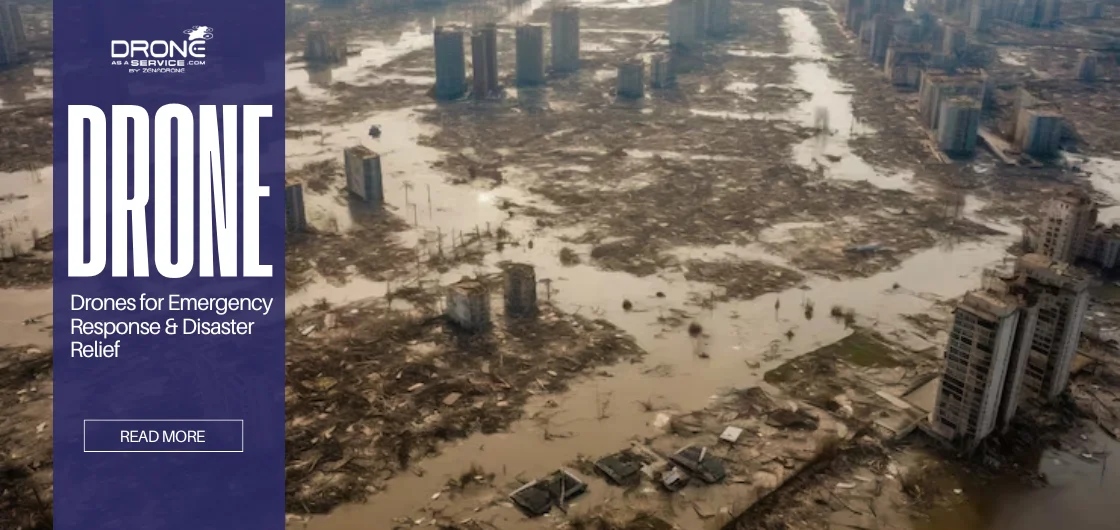
In today’s evolving disaster‑preparedness landscape, drones in emergency management are no longer experimental; they are essential. They deliver aerial views of storm-damaged areas and find people under rubble, redefining the modern relief game.
This guide discusses their features, advantages, use in the real world, and how solutions such as the ZenaDrone 1000 are taking humanitarian and public-safety operations to the next level.
What Are Emergency Response Drones?
Unmanned Aerial Systems (UAS) are emergency response drones that are specialized to carry out disaster relief, crisis management and public safety missions. These drones for emergency response are not a recreational type, unlike the previous ones, and thus they take professional-grade features, including:
Thermal Imaging Cameras
To record the presence of heat of trapped people, even in the smoke or dark.
Real-Time Video Transmission
Providing emergency organizers with real-time situation updates.
AI-Assisted Navigation
Enabling independent flight paths through insecure or inaccessible airspace.
Payload Capabilities
Ferrying small yet life-saving loads like a first-aid kit, vaccinations, or communications equipment.
These drones are not technological enhancements; they are force multipliers. They save lives by saving scarce resources, as responders do not have to physically enter dangerous areas. The contributions they make to drones in disaster management are constantly growing because of the appearance of new AI, imaging, and automation technologies.
Understanding the fundamentals of drone technology in emergency response is essential for deploying them effectively in the field.
How Drones Support Emergency Management
In the event of a disaster, the cost of a couple of seconds can be the difference. Conventional responses, such as dispatching ground crews or helicopters or waiting to get reports, often slow down action. In comparison, drones in emergency management provide fast, adaptable, and accurate information streams that enable responders to act decisively. Especially with all-weather drone technology, which allows operations during heavy rain, floods, or harsh conditions.
These are the primary ways in which drones in emergency management can change the work of an emergency:
Monitoring Hazardous Areas
Disasters usually create conditions that are far too hazardous for humans to enter, such as collapsing buildings, chemical spills, or wildfire fronts. Drones are easy to use in these situations.
- Floods: Aerial shots show the distance to which water has extended and which areas are isolated.
- Industrial Accidents: The thermal and gas sensors are used to identify the leaks or the hotspots without risking the teams.
- Wildfires: Aerial shots are used to monitor the progression of fire and locate hidden hot spots.
Drones allow agencies to survey hazards in real time, eliminating the risks to the first responders but without the risk of missing danger areas.
Providing Real-Time Situational Awareness
One of the most difficult issues in emergency management is coordination. A lack of a clear picture can lead to duplication of efforts on the part of the responders or neglect of important needs.
Aerial live video drones allow command centers to receive live feeds. Decision makers observe changing areas of disaster on screens that superimpose GIS maps and weather data. This overhead shot will ensure that the correct resources are put in the right areas.
For example:
1.) Following a hurricane, drones cover the areas to identify the blocked roads.
2.) In an urban fire, the commanders are able to determine building stability before deploying firefighters into the building.
This quick flow of data from drones for emergency response enables the coordination between the emergency units-police, fire services, and humanitarian relief forces.
Search and Rescue Operations
In situations where lives are at stake, drones with thermal cameras and infrared sensors are very important. These devices can sense the body temperature of stranded or lost people. They operate when the individual is in rubble, a forest, or a low-visibility area.
- Earthquake response: Pins down victims who are under the rubble.
- Avalanche rescues: Thermal imagery is used to scan snow-covered areas to search for heat sources.
- Night-time missions: Drones are armed with infrared and keep searching even after the helicopters have landed.
In contrast to helicopters, which are expensive and sensitive to weather conditions, drones can be deployed within minutes. This is fast and is therefore necessary in drone emergency response efforts.
Delivering Medical Supplies
The biggest challenge is usually access to disaster-afflicted areas. Roads could be submerged, bridges could collapse and debris could block up roads. Drones would overcome these barriers and deliver small but important packages to their intended recipients.
Typical deliveries include:
- First‑aid kits
- Vaccines and insulin
- Blood samples or plasma
- Communication devices
This is not an abstract concept. With the COVID-19 pandemic, drones were used in a number of countries to deliver testing kits and vaccines to isolated places.
During the large-scale disasters, this skill will be able to provide continuity of care and speed of recovery.
Insurance and Damage Assessment
Recovery is not only based on rescue but also on reconstructing lives and infrastructure. Insurance companies and government agencies are in high demand for drones to conduct damage assessments after disasters. These assessments can take different forms that range from property inspections to cost evaluations and government planning.
- Property inspections: Drones take overhead shots of rooftops, structures, and roads.
- Cost Evaluations: The insurance companies use the information to authenticate claims faster, enabling families to receive relief funds promptly.
- Government Planning: Mapping can be used to prioritize the areas that require urgent rebuilding.
The speed of recovery increases, and it also saves on cost compared to traditional inspection teams that use drones.
Real-World Emergency Drone Applications
The value of drones in disaster management is most evident when we examine real‑world missions. The earthquakes in the cities to floods in the towns, emergency drones always prove their value.
Search and Rescue Missions
Terrain hazards or infrastructure damage usually impede conventional search operations after earthquakes, floods, and avalanches.
- 2015 Nepal Earthquake: Drones assisted responders in mapping the destroyed neighbourhoods and searching the rubble to find survivors.
- Hurricane Harvey (2017 USA): Stranded residents who lived on the rooftops of flooded suburbs of Houston were rescued by emergency teams using drones.
- European Alps (Avalanches): Thermal drones are used to survey large snowfields, reducing search durations by a huge margin.
The agility of drones enables them to work in areas that helpless helicopters cannot, and this sparing of minutes can be the difference between life and death in many cases.
Disaster Response and Damage Assessment
It is a huge task to map and record the destruction post-disaster on a large scale. But drones for emergency response also collect faster, more detailed information than ground surveys.
- In California, post-wildfire, drones photographed burned homes at high resolution to assist with insurance claims.
- Drones have been used in Southeast Asia to survey the destruction on the coast after typhoons, which allows prioritized relief-supply delivery.
- Aerial mapping was used in areas of the earthquake to identify roads that were still open to aid convoys.
With drones in emergency management, agencies shorten recovery timelines and help communities rebuild sooner.
High-Risk Law Enforcement Operations
In addition to natural disasters, drones are also useful in the case of public emergencies.
- Hostage Situations: In hostage situations, drones provide the tactical teams with aerial imagery in real time, ensuring that officers are not in direct fire.
- Hazardous Materials Location: Drone technology enables the police to inspect chemical spills or dangerous packages safely without going to the location.
- Crowd Control: Drones can be used to check the safety of people during large crowds or even when a riot occurs because they keep surveying the area, avoiding any real-life confrontation with the public.
In both scenarios, drones are a force multiplier, shielding the officers and enhancing ground visibility and intelligence. This also highlights the role of drones in public safety operations, where rapid aerial insights can protect both responders and civilians.
Disaster Types Where Drones Are Deployed
Special drones in emergency response applications are needed in various emergencies. We can deconstruct the most typical pick of situations in which these tools will have a quantifiable effect:
- Wildfires: Drones with thermal cameras identify hot spots, track fire development, and guide the firefighters to safer points of entry.
- Hurricanes: Aerial surveys are used to determine storm surge, damage to infrastructure and trapped people.
- Earthquakes: Search-and-rescue drones scan the rubble of destroyed structures, discover victims and direct rescuers.
- Floods: UAVs survey flood areas, locate stranded civilians and provide lifesaving aid.
- Landslides: Terrain density drones are used to identify unstable slopes and mark blocked escape corridors.
For broader terrain mapping, resources such as a fixed-wing drone guide can help teams select the right aircraft for large-area coverage.
These prove to be versatile tools in every disaster, and they can never be overlooked in the drone emergency response mechanism.
Benefits of Using Drones in Disaster Relief
The adoption of drones for emergency response isn’t just about convenience—it’s about survival, efficiency, and resilience. Here are the key benefits:
Faster Response and Real-Time Insights
Time saved can be converted to lives saved. Helicopters require fueling, clearances, and piloting, while drones are deployed within several minutes of an event.
Using real-time aerial data, emergency teams can view the damage in real time, find survivors and allocate resources in the areas of greatest need.
Even challenges like flying drones in rain are being addressed with more weather-resistant designs.
Better Coordination and Communication
Numerous agencies, such as fire departments, police, and medical teams, as well as relief non-governmental organizations, are involved in disasters. Drones for emergency response provide a visual point of reference for everyone.
- The same live footage is viewed at command centers.
- Teams organize routes and provide drops accurately.
- Overlays such as maps or weather information are useful in the situation planning.
This single platform eliminates duplication of effort and critical areas are not missed.
Improved Responder and Public Safety
It is unsafe to send first responders to an unexplored danger zone. Drones can lessen exposure significantly by pre-scanning the regions.
- Firemen are able to view the fire spread in front of entering it.
- Rescuers are able to determine the weak points in buildings.
- Police are able to evaluate dangerous crime scenes by air.
Drones reduce the use of guesswork, thus making the job of the responders and civilians more secure.
FAA Rules and Regulations for Emergency Drones
Even in emergencies, drone work should be done within the law in order to preserve the safety of the populace. In the US, the Federal Aviation Administration (FAA) establishes regulations regarding the use of drones, and its regulations are frequently followed abroad.
Key points include:
- General Rules: Operators should have a Remote Pilot Certificate under Part 107.
- Waivers and Exemptions: In proclaimed emergencies, you may seek expedient waivers that permit flights outside of normal boundaries (e.g. at night or over individuals).
- Flight Restrictions: Temporary flight restrictions (TFRs) may be used to cover disaster areas; thus, coordination with air traffic control is necessary.
- Certification Requirements: Emergency groups have to ensure that their pilots are trained and all drones are well registered.
- Significance of Compliance: Conforming to the regulations creates confidence among regulators and the populace and ensures that shared airspace is safe.
Their non-compliance may lead to legal issues or even fatal collisions with manned aircraft, even in life-saving missions.
Popular Drones for Disaster Management
Not all these UAVs are the same. Different types of drones are constructed to take photographs; others to do farming. Durability, flight endurance, and data capabilities are the most important qualities during an emergency situation. The ZenaDrone 1000 stands out.
ZenaDrone 1000 Specifications & Features
| Feature | ZenaDrone 1000 Benefit in Disaster Relief |
| Flight Time | It has a long lifespan that enables it to sustain long rescue and mapping operations. |
| Camera System | It also has 4K video and thermal imaging, which allows it to be used at night or in a smoke-filled area. |
| Payload Capacity | It can deliver medical supplies, vaccines or communication equipment to isolated areas. |
| AI & Automation | Autonomous flight paths and obstacle sensing save on pilot efforts and speed of deployment. |
| Durability | It is also designed to be weather-resistant, ensuring reliability during storms, heavy rain, and wind. |
| Use Cases | Some of the use cases are search and rescue, damage assessment, supply delivery and hazardous zone monitoring. |
The ZenaDrone 1000 demonstrates how drones have gone beyond being flying cameras. They have become lifesaving platforms designed to address disaster relief and recovery.
Choosing the Right Emergency Response Drone Solution
Drones for emergency response that are used in disaster relief are not all appropriate. Choosing the appropriate one involves the speed, durability and usability. Drones should be evaluated by the agencies and organizations according to the following:
Speed and Automation
Emergencies do not require extensive preparation. Drones that take off immediately with pre-programmed planned flight paths cover a large area quickly and with minimum operator control. In the event of chaos, automation accelerates decision-making.
Range is also critical and knowing how far drones can fly during emergency operations ensures they cover all affected areas.
Integration and Interoperability in the system
The most effective drones in emergency management integrate smoothly with other tools. They are connected to GIS solutions, emergency radios, and AI-based analytics to create the most impact. An integrated ecosystem implies that air information directly influences physical action.
Intuition and Instructional Requirements
In disaster areas, steep learning curves would be unaffordable to responders. The perfect drone is easily operable and requires a minimum amount of training prior to use. Well-defined controls and sound automation enable teams to save lives, not debug equipment.
Not all drones can be used in disaster relief. Selecting an appropriate system involves a tradeoff concerning speed, durability and ease of use.
How Drone as a Service (DaaS) Powers Drones for Disaster Relief
Drone as a Service DaaS is leading the pack in designing the drones that are specifically designed to be resilient, fast and intelligent. With innovations in:
- AI automation: enabling drones to scan, map, and act without manual piloting.
- Smart navigation systems: ensuring safe flights in complex disaster terrain. Understanding a drone’s wind resistance capabilities is also essential for disaster missions that face strong gusts.
- Durability: weather-resistant builds for harsh storm or fire conditions.
The ZenaDrone 1000 is one example of ZenaTech’s commitment to making drone emergency response more reliable and scalable. These systems allow governments, NGOs, and emergency units to save lives comfortably.
Conclusion
Everything depends on time, safety, and precision during any crisis, be it a wildfire, flood, or earthquake. Drones for emergency response deliver all three benefits. They offer real-time situational awareness, assist in search and rescue, deliver medical supplies, and speed up recovery. Drones in disaster management are essential across the globe. They are used to merge with command systems and minimize hazards to the responders.
With the increase in size and frequency of disasters, the use of drone technology is no longer an option; it has become a necessity. Innovations such as the ZenaDrone 1000, which is made with ZenaTech technologies, revolutionize the work of humanitarian aid and enhance people’s general safety.
Are you prepared to increase your emergency response capacity? Contact us to understand how Drone as a Service (DaaS) can assist your organization in using state-of-the-art drone solutions to provide disaster relief.
Frequently Asked Questions
What is drone emergency response?
Drone emergency response refers to using drones during disaster relief and crisis operations. There are countless drone applications in emergencies, from search and rescue to medical deliveries.
How are drones used in disaster response?
Drones perform search and rescue missions, deliver medical supplies, survey flooded areas, and inspect damage.
Why are drones important for emergency management?
Drones can provide faster insights, safer reconnaissance, and reduced disaster mapping costs. They mitigate responder risk and accelerate the efforts of various agencies.
Can drones deliver medical supplies during emergencies?
Yes. Just to mention a few examples, the ZenaDrone 1000 is capable of delivering small medical kits, vaccines, or communication equipment to inaccessible disaster areas.
Are drones cost-effective for disaster management?
Yes. Drones operate at a much lower price compared to helicopters and ground surveys. It also provides detailed aerial information and instant relief efforts.