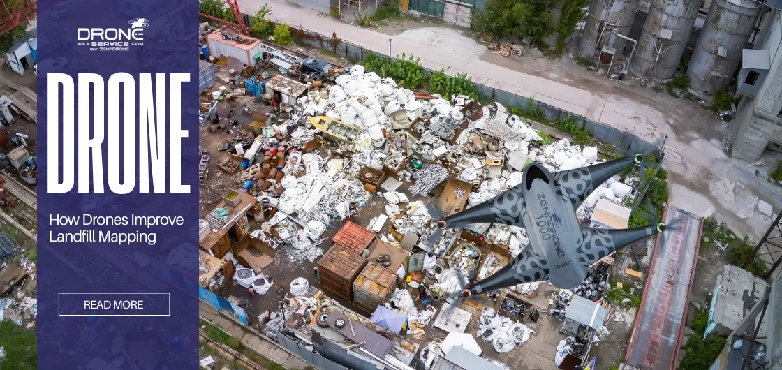
How Drones Improve Landfill Mapping
Landfills are reaching capacity, releasing hazardous gases that threaten the environment and worker safety. Traditional inspections require long, unsafe walks across unstable waste piles, yet fail to provide the high-density data needed for effective methane monitoring and risk management.
Drone landfill mapping offers a safer, faster, and highly accurate alternative. Surveys that once took days can now be completed in hours, without exposing workers to danger. UAV surveys enable:
- Improved site safety – no need for workers on unstable piles
- Faster inspections – cover large areas in a fraction of the time
- Precise data collection – support accurate methane monitoring and risk assessment
- Better environmental management – reduce emissions and operational impact
This article explores how drone landfill mapping and inspections are transforming hazardous, labor-intensive tasks into efficient, data-driven operations.
Why Drones Are Revolutionizing Landfill Surveys
Conventional landfill surveys require workers to enter hazardous areas, increasing the risk of exposure and injury. Thus, the drone for landfill mapping is offering an unprecedented leap in speed, safety, and accuracy. Key advantages of drones for landfill mapping:
- Cost Savings: Drones substantially reduce operational costs by requiring fewer personnel and reducing reliance on costly heavy equipment.
- Safety: Workers are exposed to unstable waste piles and harsh conditions. Drones inspect hazardous areas remotely to improve safety and liability.
- Speed: Traditional landfill surveys can take several days to complete. With drones, the same task can be done in just a few hours. This allows for more frequent checks—often every month instead of only once a year.
- Accuracy: Drone mapping provides highly precise aerial data that supports better decision-making. With advanced tools like high-resolution cameras, thermal sensors, and LiDAR (Light Detection and Ranging), drones capture millions of survey-accurate data points. This results in higher-quality information and improved planning.
Understanding Landfill Mapping with Drones
Drone-based landfill mapping uses aerial surveys to produce detailed, geo-referenced maps of the site. These maps are essential for monitoring capacity, tracking fill progress, and meeting regulatory requirements.
The Drone’s Main Sensors
Drones for landfill mapping can collect topographic, volumetric, and spatial data. It collects millions of points of geo-spatial data (i.e., X, Y, and Z coordinates) per site from multiple locations. This is being collected using:
- Photogrammetry: High-resolution cameras take overlapping digital images. The software utilizes these images to render accurate 3-D models and dense point clouds.
- LiDAR: Active laser sensors create surface maps of the ground. LiDAR is particularly good at penetrating vegetation on reclaimed sites in order to ascertain the underlying terrain accurately.
Advanced Data Output and Deliverables
These advanced outputs of the data make the landfill thermal inspection more actionable and usable:
- 3D Modeling/Point Clouds: These 3D modeling allow managers to visually see how much capacity is remaining and predict future needs.
- Orthomosaic Maps: These are geometrically corrected aerial photographs that are suitable for determining distances in the design process and longer-term planning while allowing for accurate measurements.
- Volumetric Calculations: Surface comparison in the digital world, using “before” and “after” surfaces, determines the volume of waste placed and remaining airspace.
Operational Applications for Drone Mapping
Use cases for drone mapping landfill sites commonly include:
- Volume Measurement: Accurate volume calculations of waste piles and stockpiles let you establish compaction rates (AUF).
- Slope Analysis: Managers can create elevation models in order to satisfy compliance, grading, and slope stability.
- Boundary Checks: Monitoring airspace against the maximum allowable Top-of-Waste (TOW).
The Importance of Thermal Inspection in Landfill Sites
Drones for landfill mapping play an important role in safety and environmental risk management efforts. It uses thermal cameras attached to the drone to measure subtle differences in temperature that go unnoticed through traditional inspection.
The main goals of a thermal inspection are:
- Fire or Hotspot Detection: As organic materials break down, they generate heat that can sometimes lead to spontaneous fires. Drones with thermal cameras monitor both surface and internal waste temperatures, helping managers detect high-temperature areas before they become dangerous.
- Methane Leak Detection: Landfills release methane, a harmful gas that poses risks to both plants and people. Thermal imaging identifies areas with heat irregularities that may indicate leaks or damage in the landfill cover, allowing for quick repairs and prevention.
Safety and Environmental Benefits
Early Warning Systems:
A landfill drone survey provides regular observations of a landfill. This can be done from a safe distance, detecting hazardous events prior to their escalation, such as fire or gas leak events. This reduces the risk for workers and community exposure to harsh and hazardous environments.
Pollution Prevention
Identifying sources of methane leaks allows technicians to identify unmitigated emissions as quickly as possible. This increases environmental compliance and control of potentially harmful pollution.
How Drone-Based Thermal Imaging Works
Drone mapping landfill sites for inspection relies on thermal sensors and infrared camera technology that recognize temperature differences. Infrared cameras recognize heat emitted, producing images that show temperatures of surfaces and even internal waste piles. UAV thermal imaging landfill technology is essential for proactively detecting temperature anomalies.
Aside from the thermal technology, drones can bring a variety of powerful complementary technologies:
Multispectral Sensors
These cameras provide an assessment of vegetation health through indices (e.g., NDVI). For example, vegetation with lower NDVI will suggest pollution discharge from gases or leachate.
Artificial Intelligence-Based Anomaly Detection
This tool analyzes patterns in data so an algorithm can automatically identify potential issues, including illegal dumpsites, which would help improve predictive maintenance on the landfill site.
Data Analytics and Visualization
All aerial methods of gathering data, such as thermal surveys, can be integrated with GIS systems and cloud initiatives. The application can notify you in real-time, set dashboards to your preferences, and create geo-spatial analyses of the concentration for quick analysis and comprehensive compliance.
For example, a thermal survey at the Radiowo Landfill in Poland completed a successful thermal inspection of the mineral capping process for breaches. This practical implementation highlights the effectiveness of the technology.
Key Benefits of Using Drones for Landfill Mapping & Inspection
The use of drones for landfill mapping resulted in improved metrics in key areas. They are cutting costs and enhancing site management in a more practical, proactive manner.
Accuracy
Drones provide precise measurements for site planning through PPK technology. It creates near-survey grade accuracy, allowing operators to accurately measure Airspace Utilization Factor (AUF). This measurement of density maximizes operational waste placement and longevity of the landfill.
Efficiency
It decreases data collection time that traditionally would take days and completes it in hours. It allows for more frequent evaluations, now monthly or quarterly, compared to annual evaluations prior to UAVs. This quicker assessment allows teams to make faster and smarter decisions.
Worker Safety
Drone surveys greatly reduce risks by handling dangerous jobs remotely. This keeps workers out of harm’s way and lowers the chance of accidents or liability.
Cost Savings
Although drones require an initial investment, they save money over time. By completing surveys from the air with fewer staff, they cut both labor and operational expenses—traditional surveys can cost around $25,000 each year.
Environmental Compliance
Drones are highly effective tools for monitoring pollution and ensuring environmental standards are met. Landfills are the third largest emitter of methane in the U.S. Drone-based systems, such as Sniffer DRONE, automate the required EPA Method 21 process to identify the exact source of a leak, contributing to increased compliance and environmental stewardship.
Common Applications of Drones in Waste Management
Drones for landfill mapping are essential tools. They improve operational safety and compliance practices for a waste management facility. Additionally, the versatile payload sensors for numerous applications, such as:
Mapping & Volumetric Surveys
Drone mapping of landfill sites can capture photogrammetry or LiDAR data and create valuable 3D models and clouds of points. These models assist in characterizing landfill growth, assessing remaining airspace, or measuring the total volumes of stockpiles for efficient inventory of material.
Leachate & Gas Detection
Drones equipped with specialized gas detection sensors or upgraded thermal cameras can evaluate methane emissions. This type of technology, like DSEM, can also automate regulatory measures by analyzing leachate and identifying leak location to evaluate environmental safety.
Thermal Inspection
Thermal cameras are a valuable asset for evaluating temperature changes. They can identify potential fire hazards in real-time to allow managers to assess the risk and act quickly on preventative measures.
Daily Monitoring
Drones can facilitate routine operations, quantify surface changes, and explore fill progression. They can also help detect illegal dumping in remote or unwatched areas, which helps sustain compliance and integrity of the site.
Environmental Assessments
Multispectral sensors can assess vegetation health (NDVI) on remediated sites for ecological risk assessments and regulatory compliance, and can flag issues such as gas infiltration or leachate failure.
Real-World Effects: Drones in Practice
The long-standing era of landfill management has come to an end. Take Hamm Inc., for example, their annual mapping could cost upwards of $25,000 or mean months of back-breaking manual labor. But that was before drones came into the picture, thanks to advancements in UAV payload performance.
Now, instead of monitoring their sites on an annual basis, they do so each month. Hundreds of complicated aerial survey photos are processed and presented as accurate, actionable 3D models within 24 hours. This speed enables managers to plan new cells and assess inventory in less than a day. Drones are more than just tools. They are a force multiplier, turning chaos into repeatable, measured efficiency in a way that has never been achieved.”
Future of Drone Technology in Landfill Monitoring
Landfill monitoring is about to be radically reshaped as we integrate autonomous drones with AI and intelligent systems, a critical transformation that guarantees a leap toward proactive, sustainable smart waste management.
These are the new technologies at the forefront of revolution:
Artificial Intelligence (AI) and Machine Learning
Drones mapping landfill sites powered by AI are not just collecting data, but also support predictive maintenance. ML algorithms automatically analyze significant data sets to identify potential problems and anomalies remotely, such as AI identifying illegal dumpsites with high accuracy on the AerialWaste dataset.
Autonomous Monitoring
Drones are shifting toward becoming fully autonomous and transitioning toward continuous presence solutions. Options for the future may incorporate swarms of autonomous drones that can automate the task coordination of equipment, elevating the efficiency of management to higher levels.
5G Connectivity
The 5G productization enables near real-time analytics and the ability to send high-resolution data quickly. This means that decision-makers now have actionable insights on aerial measurements from anywhere and in time for use.
The technologies lead to better processes and reduced emissions from vehicles along the way. Drones for landfill mapping are crucial for cleaner, greener, and smarter cities.
Smarter, Safer Landfills with Drone Technology
Imagine a future where your landfill manages itself: no workers exposed to unstable piles, just autonomous drones ensuring compliance 24/7. That future is built on today’s drone technology. The incorporation of UAVs has transformed modern waste management, making it dramatically safer, smarter, and far more economically viable. Drones for landfill mapping deliver survey-grade accuracy for every volumetric measurement, which is crucial for maximizing the precious Airspace Utilization Factor (AUF).
Crucially, drones for landfill mapping are now the frontline defense for the planet. By precisely locating and mapping methane leaks, drones are a powerful tool for achieving strict environmental compliance and dramatically reducing harmful methane emissions, the third largest source of methane in the U.S. This proactive ability to control greenhouse gases solidifies their role in long-term environmental protection.
This synergy of high-resolution mapping and UAV thermal imaging landfill inspection offers a powerful, proactive approach to asset management. It allows managers to continuously monitor spatial capacity and instantly mitigate the risk of spontaneous combustion and underground fires. Drones are not just the future of monitoring; they are the most practical, accurate, and efficient equipment available today.
Ready to seize control of your site’s safety and capacity? Contact Drone as a Service (DaaS) for advanced drone solutions for landfill and environmental monitoring.