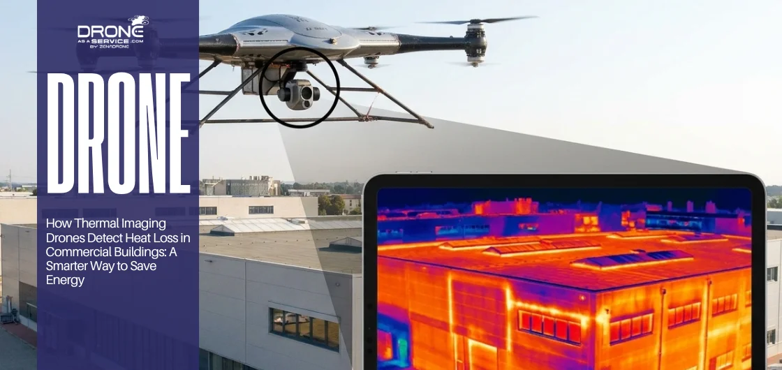
Commercial buildings silently bleed energy through insulation gaps, air leaks, and roof defects that normal inspections simply cannot find. Thermal imaging drones fix this problem-solving gap by scanning entire building envelopes quickly, safely, and without disrupting daily operations. The result is a detailed heat map showing exactly what is leaking, where it is, and how urgently it needs attention. Lower energy bills, better comfort for occupants, and a prioritized repair plan backed by strong visual evidence.
The Silent Energy Thief Nobody Is Talking About
Energy bills that are silently and unnecessarily raised are paid by commercial building owners on a monthly basis. Near windows, tenants experience a shivering sensation. Staff members accumulate at their desks. Facility managers are perplexed by HVAC systems that are unable to keep pace.
Heat is escaping undetected from the walls, the roof, or the loading bay doors. The most frustrating aspect is that the majority of this loss can be entirely prevented.
The even more frustrating part is that you simply cannot see it with the naked eye. This is where real problem-solving with thermal imaging drones changes everything.
Using drone-based thermal inspection allows for a comprehensive view of heat loss without the need for invasive methods like wall demolition. This technology is revolutionizing the way professionals conduct drone surveys in Ireland, enabling them to create accurate 3D building models quickly and safely. By adopting this innovative approach, organizations can reduce costs, meet sustainability goals, and effectively address energy waste issues.
What Thermal Imaging Drones Actually Are and Why They Work
A thermal imaging drone can be compared to a flying infrared eye. It does not perceive color or texture in the same way as a traditional camera.
To be more precise, it captures the infrared radiation emitted by surfaces and converts these readings into vivid, color-mapped images that illustrate the precise location of temperature fluctuations. A thermal image may reveal a glowing orange patch that indicates the absence of insulation, although the wall appears to be in perfect condition to the naked eye.
A roof that passed its last manual check might show cold blue streaks where moisture has crept in and degraded the insulation layer beneath. Traditional inspections miss these issues completely because they rely only on what is visible. Thermal drones cut straight through the surface and expose what is actually happening underneath.
Why Heat Loss Hits Commercial Buildings Harder Than You Think
For a domestic property, heat loss is inconvenient and costly. For a commercial building, it compounds into a problem that touches everything from tenant satisfaction to carbon reporting.
When heat escapes through a poorly sealed roof or an insulation gap above a suspended ceiling, the HVAC system compensates by running longer, working harder, and wearing out faster. It consumes more energy per hour while the interior temperature stays uneven. Staff near the perimeter are cold while colleagues near the core are warm, and complaints come from both directions.
Then there is the sustainability angle. Businesses under ESG frameworks or pursuing carbon reduction targets cannot afford hidden inefficiencies. Every kilowatt wasted through a thermal bridge or a gap around a rooftop unit actively works against your environmental commitments and eventually your bottom line.
Real problem-solving at this level requires knowing exactly what is leaking, where it is, and how severely it is affecting performance.
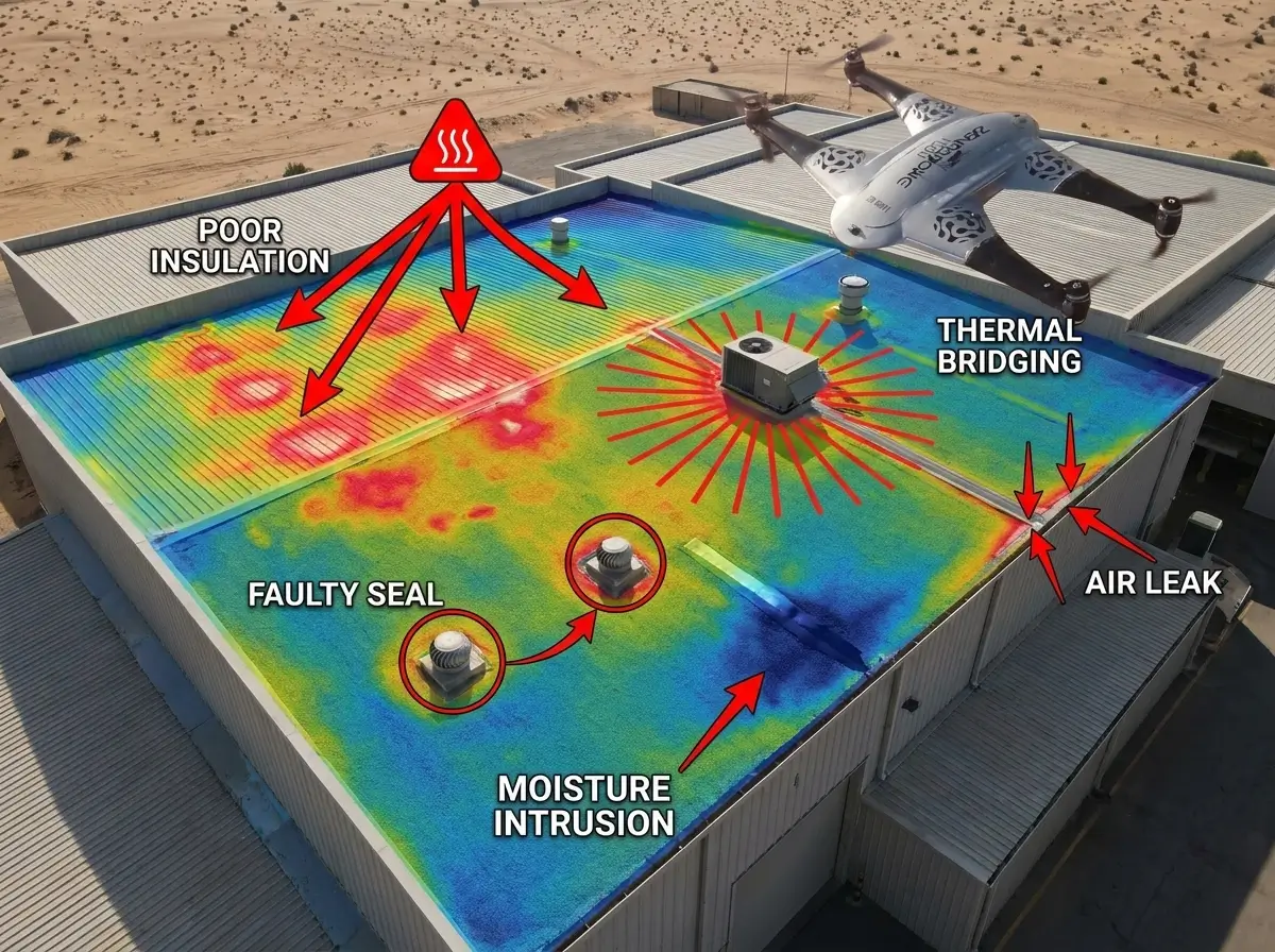
The Heat Loss Culprits That Thermal Drones Catch Every Time
Heat loss in commercial buildings is rarely one single issue. It is usually several problems layered on top of each other, scattered across a large surface area, and completely invisible to anyone standing at ground level.
Poor Roof Insulation
Flat commercial roofs are notorious for compressed, shifted, or moisture-saturated insulation. In a thermal image, these areas appear distinctly warmer in winter because heat is rising straight through the roof deck unchecked.
Air Leakage
Air leakage creates invisible pathways through gaps around windows, doors, loading bay shutters, and mechanical penetrations. Tenants often notice these first, and investigators often investigate them last.
Thermal Bridging
Steel-framed buildings are particularly susceptible to thermal bridging. The original design did not account for the fact that metal conducts heat more readily than the insulation materials in its vicinity, resulting in the formation of pathways that facilitate the transfer of heat through the building envelope.
Moisture-Damaged Insulation
Moisture-damaged insulation is a hidden liability. Once water infiltrates an insulation layer, its thermal resistance drops sharply. What was once an effective barrier quietly worsens for years without anyone noticing.
Faulty Seals Around Rooftop Equipment
Faulty seals around rooftop equipment are among the most common failure points on commercial roofs. HVAC units, extraction fans, skylights, and pipe penetrations all need proper sealing, and these joints are notoriously easy to overlook during routine visual checks.
How This Problem-Solving Approach Works Across Different Building Types
The problem-solving value of thermal drones becomes obvious when you look at real building scenarios. Each building type has its own challenges, and thermal technology addresses them all.
Office Buildings
Office buildings frequently suffer from uneven temperatures between floors or across open-plan areas. These often trace back to insulation discontinuities in the building envelope. Thermal drones map these inconsistencies precisely, removing the guesswork from what is often a very expensive diagnostic process.
Warehouses
Warehouses present a different challenge. A large industrial roof can span thousands of square meters. Manual inspection of a surface that size via cherry picker or scaffolding is time-consuming, costly, and often incomplete. A drone covers the entire area in a single flight, flagging weak spots with millimeter-level detail.
Retail Properties
Retail properties suffer commercially when drafts near entrance areas frustrate customers. Poor seals around automatic doors or shopfront glazing do not just annoy staff. They quietly affect dwell time and revenue. Thermal inspection identifies exactly where air is infiltrating.
Industrial Facilities
Industrial facilities have complex roof profiles with numerous penetrations, plant rooms, and extraction systems. Manually tracking the sealing and insulation condition across all of these is practically impossible. Drone-based thermal surveys make that problem manageable.
Multi-Tenant Commercial Buildings
Multi-tenant commercial buildings frequently see disputes over energy costs where multiple occupants share a building’s services. Thermal imaging provides objective visual evidence of where energy is lost, which landlords and tenants can use in conversations to help allocate responsibility fairly.
The Real Advantages Over Older Inspection Methods
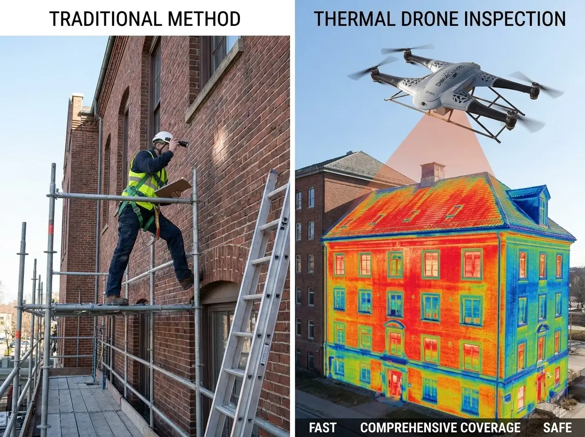
This is not about dismissing traditional inspection approaches. It is about understanding their shortcomings and why thermal drone surveys address those gaps so directly.
A visual inspection tells you what the surface looks like today. A handheld thermal camera gives you close-up readings in accessible areas. Neither gives you a comprehensive, systematic picture of an entire building envelope in a single workflow.
This is precisely what thermal imaging drones accomplish. They rapidly cover expansive surface areas without the need for scaffolding, without the risk of rooftop access, and without disrupting building operations.
| Method | Strengths | Limitations |
|---|---|---|
| Visual Inspection | Simple, low-cost | Misses hidden heat loss entirely |
| Handheld Thermal Camera | Good for targeted close-range checks | Limited reach, slow over large areas |
| Thermal Imaging Drone | Fast, full-envelope coverage, safer access, detailed data | Requires proper weather conditions and qualified analysis |
The problem-solving advantage that drones have over the first two methods is not incremental. It is structural.
Getting the Conditions Right for Accurate Results
Like any precision tool, thermal imaging drones produce their best results when the conditions are right. The physics of infrared thermography depend on temperature contrast. The bigger the difference between inside and outside, the clearer and more diagnostic the thermal image.
The Temperature Differential
The temperature differential should ideally be at least 10 degrees Celsius between the building’s interior and exterior. This ensures heat-loss signatures are strong enough to register clearly on the thermal sensor.
Weather Conditions
Weather conditions play a major role. Cold, overcast days are ideal. Rain, high wind, and direct sunlight all introduce noise into thermal readings. Sunshine in particular heats surface materials unevenly, which can create false hot spots and obscure genuine heat loss patterns.
Time of Day
Time of day matters more than most people realize. Early morning is typically the best window. Solar heating has not yet affected surface temperatures, and the building has been warmed overnight. Evenings work well for the same reason. Midday surveys during sunny periods are generally avoided.
Getting these conditions right is part of the expertise a professional provider brings. Surveying at the wrong time does not just produce poor results. It can produce actively misleading ones, which defeats the entire purpose of the problem-solving exercise.
What a Professional Thermal Drone Survey Actually Involves
A credible thermal drone inspection is not a quick flyover followed by a handful of screenshots. It is a structured process that begins before the drone leaves the ground and ends with a report detailed enough to hand directly to a contractor.
Pre-Flight Planning
Pre-flight planning involves reviewing building drawings and layouts, identifying areas of known concern, and establishing the flight path to ensure complete envelope coverage with no gaps.
Dual Imaging
Dual imaging is advisable to employ in all situations. The thermal image identifies the anomaly, while the visible image confirms its precise location on the building when both thermal and visible light imagery are captured simultaneously. This combination is indispensable for reports that maintenance teams can implement.
Systematic Roof and Facade Mapping
Systematic roof and facade mapping ensures the drone works methodically across the entire building exterior, covering the roof, walls, glazing lines, junctions, and penetrations. Nothing is assumed to be fine simply because it looks fine.
Anomaly Identification and Severity Grading
Anomaly identification and severity grading distinguishes genuine heat loss from expected temperature variation. Experienced thermographers interpret data in the context of building construction and grade each finding by severity to help prioritize action.
Detailed Reporting
Detailed reporting combines thermal and visible imagery with precise location mapping, written findings, severity assessments, and recommended remedial actions. The document should be clear enough for a facility manager to understand and detailed enough for an energy auditor to use.
Follow-Up Verification
Follow-up verification after repairs confirms that the work resolved the issue, closing the loop and providing documented evidence that we actually made improvements.
Turning Thermal Data Into Meaningful Action
The survey itself is only valuable if the results drive real decisions. Building owners who benefit most from thermal inspections use the data in several concrete ways.
Prioritization of Repairs
Prioritization of repairs is the foremost advantage. Not all occurrences of heat loss require prompt intervention. Thermal data allows for the prioritization of issues according to their severity, facilitating the resolution of roof insulation failures that result in annual costs in the thousands prior to addressing the comparatively minor air leakage at a service door, which is substantially less costly.
Targeted Insulation Upgrades
Targeted insulation upgrades save significantly on materials and labor. Rather than replacing insulation across an entire roof or facade, thermal surveys identify the specific zones that have actually failed.
Planned Maintenance Scheduling
Planned maintenance scheduling means repairs can be budgeted for and scheduled during quieter periods rather than handled reactively mid-winter at emergency rates.
Retrofit and Refurbishment Justification
Retrofit and refurbishment justification becomes far easier when thermal evidence quantifies the problem in degrees and square meters. That data translates cleanly into projected energy savings and return-on-investment calculations for budget approval.
ESG and Sustainability Reporting
ESG and sustainability reporting benefits from this kind of documented evidence. For businesses working toward net-zero targets or compiling annual sustainability reports, thermal survey data carries genuine credibility.
Mistakes That Undermine the Value of Thermal Surveys
For all their capability, poor execution or misinterpretation can undermine thermal drone surveys. These are the errors that turn a useful problem-solving tool into an expensive exercise in inconclusive data.
Surveying in the Wrong Conditions
Surveying in the wrong conditions is the most common mistake. Flying in direct sunlight, high winds, or immediately after rain produces data that is difficult to interpret accurately. A provider who prioritizes speed over conditions is neglecting important aspects.
Treating Every Hot Spot as a Defect
Treating every hot spot as a defect is another pitfall. Thermal images need to be read in context. A warm patch above a recessed light fitting is very different from a warm patch in the middle of a flat roof. Without building science knowledge, data gets misread, and the wrong repairs get commissioned.
Skipping the Visible-Light Comparison
Skipping the visible-light comparison makes precise location identification much harder. A contractor needs to know exactly where on the roof to look, not just that there is an anomaly somewhere in the northeast quadrant.
Failing to Follow Up
Failing to follow up after repairs leaves the problem-solving loop open. Knowing where the problem is and confirming the fix has worked are two different things. Both matter equally.
What to Look for When Choosing a Provider
The personnel responsible for conducting a thermal drone inspection have a substantial impact on its effectiveness. Technology functions as an instrument. It is advantageous due to its proficiency.
When evaluating providers, look for genuine experience with commercial buildings rather than generalist drone operators who have simply added a thermal camera to their kit. Commercial building thermography requires an understanding of construction methods, insulation systems, HVAC integration, and building physics that goes well beyond knowing how to fly a drone.
Check that they use radiometric thermal cameras, which record precise temperature data at every pixel rather than just producing a color image. This makes the data measurable, comparable, and verifiable over time.
Confirm their operations comply with local aviation regulations. In Ireland, this means operating under Irish Aviation Authority approval. Also confirm that contractors and facility managers can genuinely act on their reporting format because it is detailed enough.
Ask specifically about their problem-solving approach. How do they handle ambiguous readings? What is their process when conditions are not ideal? How do they communicate findings to non-technical stakeholders? These questions quickly reveal whether you are dealing with a capable diagnostics partner or simply a drone operator with a thermal attachment.
Conclusion
Rising energy bills are a predictable and avoidable problem in commercial property management. The heat loss driving those bills is almost always detectable, quantifiable, and fixable. The challenge has always been finding it efficiently, safely, and at a scale that makes sense for large buildings.
Thermal imaging drones solve that challenge directly. They cover more ground, find more issues, and provide clearer evidence than any traditional inspection method. More importantly, they transform a frustrating, open-ended question like “why are our energy bills so high?” into a structured, prioritized action plan.
For building owners and facility managers who are serious about energy performance, occupant comfort, and meeting sustainability commitments, thermal drone inspections are not a luxury. They are the smartest problem-solving investment you can make in your building’s long-term performance.
Frequently Asked Questions
Get a Thermal Imaging Drone Survey for Your Commercial Building
Stop bleeding energy through invisible gaps and poor insulation. Our certified thermal imaging specialists deliver comprehensive drone surveys that pinpoint exactly where heat is escaping, how severe each issue is, and what repairs will deliver the biggest returns. We provide detailed reports with thermal and visible imagery, severity assessments, and actionable recommendations — everything you need to lower energy costs, improve comfort, and meet your sustainability targets.