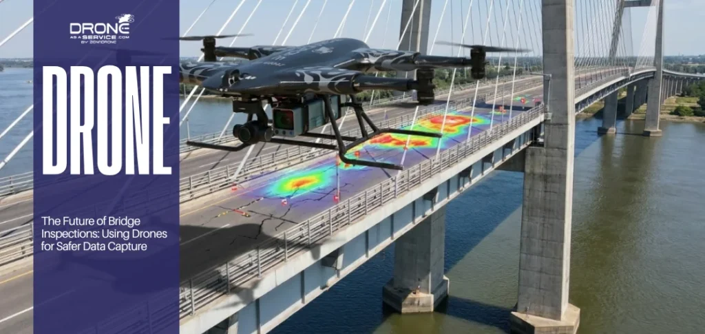
LiDAR surveys are transforming how Irish construction teams collect and use ground data. Where traditional methods took days and missed key variations, LiDAR delivers dense, accurate 3D data in a fraction of the time.
That speed translates into better decisions teams are working from accurate ground data rather than assumptions that fall apart once the groundwork starts.
Costly mid-build surprises become far less common, and when conditions do change, it’s much easier to adapt without throwing the whole programme off track.
Introduction
Many construction projects in Ireland run into similar problems. Ground conditions are rarely uniform, weather can shift quickly, and in many cases, the survey data being used no longer reflects what’s actually on site.
Traditional surveying methods still depend heavily on manual fieldwork. While they’re reliable, they take time and often only capture selected points rather than the full surface. That means small variations in terrain can go unnoticed, and those gaps tend to surface later during design or construction, often as delays, revisions, or added costs.
LiDAR changes that picture quite a bit. Rather than picking up a handful of points across a site, laser scanning pulls in the whole picture, every contour, every level change, all of it captured in sharp 3D detail that actually reflects what’s on the ground.
For engineers and site managers, that kind of clarity is worth its weight in gold. Less guesswork going into a project means fewer unwelcome discoveries once the diggers move in.
This article covers five reasons why LiDAR surveys are proving so useful on Irish construction projects. It also examines how the technology is applied in real-world situations, along with practical examples and best-practice guidance, so you can understand where it adds value and how to use it effectively.
The Growing Importance of LiDAR in Irish Construction
Construction in Ireland has become noticeably more challenging in recent years. In many urban areas, space is tight, and planning requirements are more demanding than they used to be. That combination alone puts a lot more pressure on getting site information right from the very beginning.
When the base data isn’t accurate, things start to slip quickly. Even small errors at an early stage can create knock-on effects later, whether that’s delays in approval, design changes, or unplanned cost increases.
The photogrammetry vs LiDAR debate comes up regularly on site, and most teams have had to work through that decision at some point. It usually comes down to the detail required, how demanding the terrain is, and how much accuracy the project simply can’t afford to get wrong.
Traditional surveying methods are still widely used, but they typically rely on taking individual point measurements. In practice, that means you’re only capturing parts of a site rather than the full surface.
On more complicated sites especially where access is limited or ground conditions vary, that approach can leave gaps in the data. Those gaps might not look like much at first, but they often become a problem once design work starts.
LiDAR works differently. It captures dense point data across the entire site in a short amount of time, building up a far more complete picture of what’s actually there on the ground.
As construction becomes more digital, the need for reliable geospatial data has grown as well. Tools like 3D modelling and BIM depend heavily on accurate input data to function properly. Without that foundation, the models lose a lot of their value.
That’s why LiDAR has started to play such a central role it provides the level of detail these systems need to actually work the way they’re intended to.
Benefit 1: High-Precision Data Collection
Small surveying errors have a way of catching up with you. A slight miscalculation in levels or boundary positions might look minor on paper. Still, once construction gets underway, that margin can quickly turn into a structural headache or an unbudgeted expense. It’s a particular concern on larger infrastructure projects where tolerances leave very little room for error
What LiDAR does differently is capture an enormous density of measurements right across the site. Rather than working from a handful of survey points and filling in the gaps, you’re getting a continuous read of the actual ground surface which gives the whole project team a much more solid foundation to work from.
That level of detail makes it easier for engineers to work with confidence. When the model more closely matches real site conditions, there’s less need to revisit designs or redo work because something doesn’t line up on site.
In Ireland, where the terrain can change quite a bit even within a single site, that accuracy really matters. It supports better drainage design, more reliable structural alignment, and helps ensure projects stay in line with engineering and environmental requirements.
Benefit 2: Faster Survey Turnaround
Surveying delays have a way of rippling through the entire build program. Traditional methods often mean multiple trips back to the site, followed by hours of manual processing once the team is back in the office. All of that adds up and can easily stretch project timelines beyond what was planned.
With more modern methods, what once took several days on site can often be completed in a single visit, with processing done shortly after. Large areas can be captured relatively quickly compared to conventional techniques.
The real advantage is the speed with which usable data becomes available. Once teams have that information, they can move into planning and design without sitting around waiting for survey cycles to finish.
For contractors working against tight deadlines, that speed makes a noticeable difference. It keeps things moving and cuts down on those repeat site visits that eat into the program before work has even properly started.
Benefit 3: Improved Safety on Site
Some areas of a construction site are simply hard to reach, and in the early stages, that can also be unsafe. Steep ground, loose or unstable surfaces, and active machinery zones all add a layer of risk. In traditional surveying, this often means surveyors still have to enter these areas to collect measurements physically.
With LiDAR, that changes quite a bit. When mounted on drones or vehicles, data can be collected remotely without sending people into hazardous locations. That alone reduces a lot of unnecessary exposure, particularly on sites where conditions aren’t stable. You still end up with detailed and accurate survey data, but without the same level of on-the-ground risk.
In Ireland, where the weather can shift quickly and site conditions can deteriorate without much warning, this becomes even more useful. It keeps people out of harm’s way and supports a safer way of working across the site.
Benefit 4: Enhanced Project Planning and Visualization
When the site isn’t fully understood early on, design decisions made in those first weeks have a tendency to unravel later. If the terrain or existing structures haven’t been properly captured, problems tend to surface once construction is already underway and by that point, fixing them costs far more than it would have earlier.
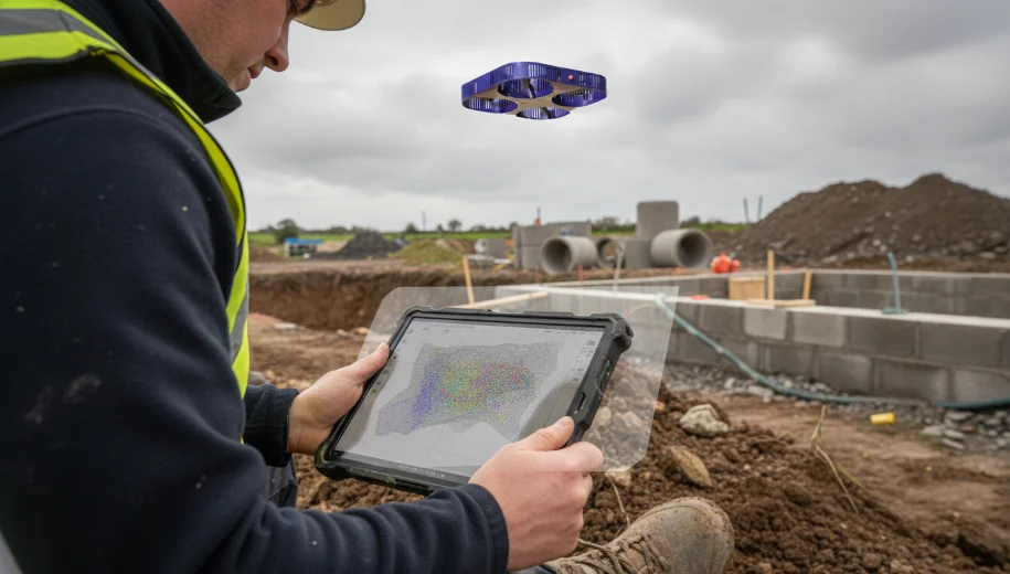
Accurate 3D models give everyone an honest picture of what’s actually on the ground before a single sod is turned. That shared understanding makes it much easier to catch conflicts at design stage, when sorting them out is still straightforward.
Where it becomes even more useful is when that data feeds into BIM workflows. Teams can run simulations, pressure-test different approaches, and work from the same reliable information rather than each drawing their own conclusions from incomplete site data.
Benefit 5: Cost Efficiency and Reduced Rework
A lot of unexpected costs in construction trace back to the survey stage. Sometimes it’s a small measurement that’s slightly off; other times, it’s ground conditions that weren’t picked up in enough detail. Either way, finding out once work has started is rarely cheap.
Having detailed site data from the beginning changes that. Instead of filling gaps with assumptions during planning, teams actually know what they’re working with which means fewer surprises mid-build and less going back over work that should have been right the first time.
For companies using drone surveying in Ireland, that translates into something tangible. Materials, excavation, earthworks all of it can be planned from real numbers rather than rough early estimates. And because the data is there from day one, there’s no scrambling to fill gaps halfway through a project. That level of accuracy accumulates over a project and helps keep costs on track.
Practical Applications from Irish Construction Projects
Rural Infrastructure: Drainage Design Saved by LiDAR
On one rural infrastructure project in Ireland, the ground had other ideas. Some key elevation changes were missed during the original survey, and it wasn’t long before that gap started affecting how the drainage was laid out. When LiDAR was later introduced, those variations became much clearer, and the design could be adjusted before any major construction work began.
Urban Redevelopment: Clash Detection in Tight Spaces
There was a different situation in an urban redevelopment project where space was extremely limited. Working in that kind of environment is always tricky because everything is so tightly packed. LiDAR provided a highly accurate map of existing buildings and underground utilities, making it easier for engineers to refine the design and avoid clashes once construction began.
On another commercial site, things didn’t go as smoothly. The project moved forward using survey data that was already outdated. When work got underway, the ground told a different story. Terrain variations that hadn’t been accounted for started causing delays and driving up excavation costs. LiDAR was eventually brought in to get the picture straight, but by then, some of the extra time and money had already been spent. These kinds of delays are becoming less common among teams that bring in drone survey providers in Meath early – before groundwork begins rather than after problems surface.
Best Practices & Professional Checklist
Planning
Getting LiDAR to actually deliver on a project starts well before anyone sets foot on site. If the scope isn’t nailed down early, there’s a real chance the data that comes back won’t match what the team needs when it matters. Surveyors and engineers need to be on the same page from the outset, not playing catch-up later.
Execution
Out on site, the quality of what you get back depends on the equipment being properly calibrated and the people operating it knowing what they’re doing. Ground control points and cross-verification are worth the effort raw data on its own isn’t enough to lean on. Keeping consistency across the whole site also matters, because gaps or mismatches have a way of causing headaches once everything gets pieced together.
Data Processing
Post-processing is where a lot of projects let themselves down. The data needs to be properly worked into BIM or GIS systems before it’s any use in design or decision-making. And before anything gets handed over for construction use, quality checks should always be done not as a box-ticking exercise, but because that’s what makes the information actually reliable.
Practical Checklist for Professionals
- •Clearly define the survey scope and required accuracy
- •Work with experienced LiDAR survey teams
- •Validate results using ground control points
- •Ensure proper integration with BIM/GIS workflows
- •Carry out final quality assurance checks before use
Limitations & Future Direction
Limitations
LiDAR isn’t without its limitations. Dense vegetation can get in the way of a clean ground read, reflective materials can throw off the data, and the sheer size of the datasets means you need people who actually know how to handle them properly.
- •Vegetation interference: Dense tree cover or shrubland can obstruct a clean ground read, requiring additional filtering during post-processing.
- •Reflective surfaces: Glass, water, and certain metals can throw off the sensor data and introduce errors into the point cloud.
- •Dataset size and expertise: Large point cloud files demand skilled operators and specialist software to process correctly.
- •Upfront cost: On smaller projects, the investment needs to be weighed against potential savings from avoided rework and better planning decisions.
Future Trends
Where things are heading is interesting. LiDAR is becoming more tied into automation and real-time processing, and as the sensor technology keeps improving, so does the accuracy. It’s moving from being a specialist tool to something that’ll likely just be a normal part of how construction sites are managed day to day.
- •Automation and real-time LiDAR processing are streamlining field-to-office data workflows.
- •Sensor improvements continue to push accuracy levels beyond current centimeter-level benchmarks.
- •Integration with AI-powered analysis tools is making it easier to extract actionable insights from large point cloud datasets.
- •Hybrid approaches combining LiDAR with photogrammetry are becoming standard practice for complex Irish construction projects.
Conclusion
LiDAR has found its place in Irish construction fairly quickly, and it’s easy to understand why. Going into a project with a clear picture of what’s actually on the ground changes how decisions get made and more often than not, for the better.
It takes a lot of the guesswork out of early planning, keeps different teams working from the same information, and heads off the kind of problems that usually only surface once work is already underway.
As projects get bigger and more complex, having that level of ground truth isn’t really optional anymore. It’s just become part of how construction gets done.
FAQs
Get Accurate LiDAR Survey Data for Your Irish Construction Project
Whether you need precise terrain mapping, structural inspections, or BIM-ready point cloud data, our certified team delivers compliant, accurate LiDAR surveys tailored to your project requirements across Ireland.