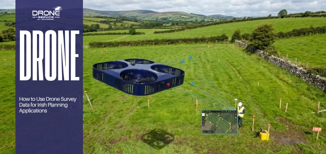
From raw aerial data to a compliant planning submission: what surveyors, architects, and project managers in Ireland actually need to know
Let me be direct about something most drone blogs won’t say outright: many planning applications in Ireland fail or get delayed not because the design is wrong, but because the site documentation is weak.
The drawings are generic, the surveys are outdated, or the topographical data doesn’t match what the planning officer can see with their own eyes on Google Maps. That last one happens more than you’d think.
Drone survey data provides a clear and reliable foundation for planning applications. By supporting submissions with high-resolution aerial imagery, detailed photogrammetric terrain models, and accurately georeferenced orthophotos, developers can present site conditions with precision. This level of detail helps local authorities assess projects more efficiently, as decisions are based on verifiable visual evidence rather than assumptions or incomplete ground-level information.
This isn’t theoretical. Across commercial, agricultural, residential, and infrastructure projects throughout Ireland, drone-derived survey data is increasingly appearing in planning packages, and projects that include it tend to move faster and receive fewer requests for further information (RFIs). That alone makes the investment worthwhile.
Here’s how it actually works, what the regulations require, and how to use it properly.
What Drone Survey Data Actually Gives You
Before getting into the mechanics of planning submissions, it’s worth being precise about what drone survey data is and what it isn’t. People often conflate aerial photography with survey-grade data, and that distinction matters enormously when you’re producing documents for a statutory process.
A standard drone photo captures imagery. Useful, but not metrically reliable on its own. Survey-grade drone data, collected using RTK (Real-Time Kinematic) GPS or GCP (Ground Control Point) workflows and processed through photogrammetric software, produces outputs with measurable spatial accuracy typically within 2–5 cm horizontal and 3–8 cm vertical, depending on flight parameters and ground control setup.
What you can derive from that data:
- ▸
Orthomosaic maps — geometrically corrected aerial images suitable for scaled drawings - ▸
Digital Terrain Models (DTMs) — bare-earth elevation data with vegetation removed - ▸
Digital Surface Models (DSMs) — surface elevation including structures and vegetation - ▸
Contour data — automated or manually derived contour lines at any interval - ▸
Point clouds — 3D datasets usable in CAD, BIM, and GIS environments - ▸
Volume calculations — cut-and-fill, stockpile, and earthwork computations - ▸
3D models — textured mesh models of sites, structures, and landforms - ▸
Site boundary confirmation — boundary verification overlaid on OS basemaps
Each of these is directly relevant to planning applications. The question is knowing which outputs your project actually needs, and how to integrate them into a submission that satisfies the local authority.
The Planning Context in Ireland
Irish planning law operates under the Planning and Development Act 2000 (as amended), with applications made to local planning authorities, the 31 county and city councils, or, for strategic infrastructure, directly to An Bord Pleanála.
The requirements for application documentation are set out in the Planning and Development Regulations 2001 (as amended), and supplemented by development plans, local area plans, and county-specific guidance notes.
None of these explicitly mandates drone surveys. What they do mandate or strongly expect is accurate, scaled, georeferenced survey data. The collection method has largely been left to the applicant. What matters is the output quality.
Regulatory Note: All commercial drone operations in Ireland fall under the Irish Aviation Authority’s (IAA) regulatory framework, which aligns with EASA regulations. Operators must hold appropriate authorization for the flight’s operational category. Before contracting any drone survey for planning purposes, confirm your provider holds valid IAA approval.
This isn’t a minor administrative detail. Data collected under an unauthorized operation can create liability issues and, in rare cases, admissibility concerns. Where drone data specifically earns its place in planning is in the quality and currency of topographical information. Traditional ground-based surveys are accurate but slow, expensive for large sites, and can be difficult to execute safely on steep, vegetated, or structurally complex terrain. A drone captures the same, or more data in a fraction of the time, with no access risks.
Where Drone Survey Data Fits in a Planning Application
A standard planning application in Ireland typically requires several key documents, including application forms, site location maps, layout plans, elevations, cross-sections, planning statements, and any necessary technical reports. Drone survey data can support many of these requirements by providing accurate site information, detailed aerial imagery, and reliable mapping data that improves the quality and accuracy of planning submissions.
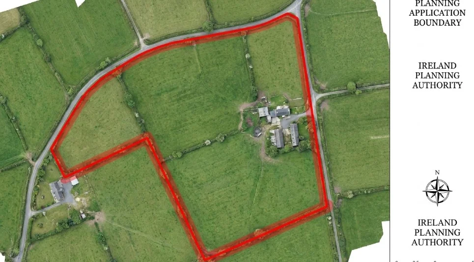
1. Site Location Map and Site Layout Plan
Orthomosaic imagery provides an accurate, up-to-date aerial base for site boundaries, access points, and context mapping. Far more reliable than OS base maps for showing current conditions, particularly on greenfield, agricultural, or brownfield sites where the landscape has changed since the last mapping update.
2. Topographical Survey
Drones bring real advantages here. Any development that involves earthworks, drainage, or flood risk assessments depends on accurate topographic data. Drone-generated Digital Terrain Models (DTMs) and contour outputs can replace or complement traditional ground surveys, usually at a lower cost and with faster turnaround times.
3. Visual Impact Assessment (VIA)
In sensitive environments such as wind farms, rural housing, and agricultural buildings near protected vistas, planning authorities often require photomontages or viewshed analyses. Drone imagery and 3D models provide the accurate baseline needed to carry out effective visual impact assessments.
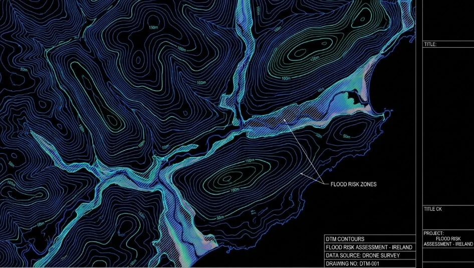
4. Flood Risk Assessment
The OPW’s Flood Risk Management Guidelines require that applications in flood-risk areas include site-specific flood risk assessments. Accurate ground-level data elevation, drainage patterns, and proximity to watercourses are foundational to this work. Drone-derived DTMs with 2–5 cm vertical accuracy significantly improve the reliability of these assessments.
5. Ecological and Landscape Context
Where ecological surveys are required (and increasingly, they are), drone data helps ecologists map habitat types, assess connectivity, and document baseline conditions before development. Multispectral drone data can distinguish vegetation types in ways that ground survey alone cannot.
6. Existing Structures and As-Built Documentation
Particularly relevant for extensions, change-of-use applications, and developments affecting existing buildings. Drone photogrammetry produces accurate 3D models of existing structures that form the basis for elevation drawings and design proposals.
Accuracy Standards: What Planners and Engineers Actually Need
This is where a lot of drone survey projects go wrong. There’s a tendency among some operators to treat every drone flight as inherently “survey grade” — it isn’t. Accuracy depends on the sensor, the flight parameters, the ground control setup, and the processing workflow.
“Accuracy isn’t a product of the drone — it’s a product of the methodology. Two operators flying the same aircraft can produce data with an order of magnitude difference in positional accuracy.”
For planning applications, the relevant accuracy benchmark in Ireland typically follows Ordnance Survey Ireland (OSi) standards and the requirements of the relevant professional bodies — the Society of Chartered Surveyors Ireland (SCSI) and Engineers Ireland. In practice, most planning submissions require survey data accurate to:
- ▸
Horizontal: ±50mm or better for topographical surveys - ▸
Vertical: ±50mm or better, particularly for drainage and flood risk work - ▸
Absolute accuracy tied to Irish Transverse Mercator (ITM) or Irish Grid (IG) coordinate system - ▸
Ordnance Datum Malin (ODM) vertical datum for height references
Delivering survey-grade accuracy requires a robust ground control process. This typically involves using established survey control points or temporary ground control points (GCPs) measured with GNSS survey equipment, along with independent checkpoint validation.
Professional drone survey providers in Ireland should supply an accuracy assessment report with their final deliverables, confirming that the data meets the required standards. The absence of documented accuracy verification can raise concerns about the reliability of the survey results.
RTK vs GCP Workflows
Modern survey drones increasingly use onboard RTK GPS, which improves absolute accuracy without the labor of placing and surveying GCPs across the site. For large or complex sites, a hybrid approach — RTK drone with a smaller number of GCPs for verification — typically delivers the best combination of efficiency and accuracy. For planning purposes, independent checkpoint verification remains best practice regardless of which workflow you use.
The Process From Flight to Planning Submission
Understanding the workflow helps project managers set realistic timelines and understand what they’re actually commissioning.
1. Pre-flight Planning and Airspace Authorization
The operator coordinates with the IAA for higher-risk operations, checks NOTAM restrictions, and identifies operational constraints such as proximity to aerodromes, populated areas, or sensitive infrastructure. At this stage, the operator also defines the required accuracy, expected outputs, and coordinate reference system.
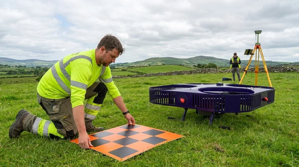
2. Ground Control Survey
GCPs are established across the site using GNSS survey equipment. Their positions are measured with high accuracy and recorded for use in data processing. This step is frequently the difference between survey-grade output and decorative aerial photography.
3. Data Capture
The drone flies pre-planned routes at appropriate altitude, overlap, and ground sample distance (GSD) for the required output accuracy. For a planning-grade topographic survey, 80–90% image overlap is typical. Flight time depends on site size — a 5-hectare site might take 30–45 minutes of actual flight.
4. Photogrammetric Processing
Raw images are processed through software such as Agisoft Metashape, Pix4D, or DJI Terra to generate point clouds, DSMs, DTMs, and orthomosaics. GCPs are incorporated at this stage. Processing time for a planning-scale site typically runs 2–8 hours on modern hardware, sometimes longer for larger or more complex datasets.
5. QA and Accuracy Verification
Independent checkpoints are measured at locations that are excluded from the photogrammetric processing workflow. The coordinates generated from the drone survey are then compared against these surveyed checkpoint positions to assess accuracy. This validation process produces a documented accuracy report, providing clear evidence of the survey’s precision and reliability.
6. Data Delivery and Integration
The team delivers outputs in formats that fit directly into the project workflow: DWG/DXF for CAD, GeoTIFF for GIS, LAS/LAZ for point clouds, and IFC for BIM integration. A good survey provider discusses deliverable formats at the outset, and retrofitting data to an incompatible format wastes time.
7. Integration into Planning Documents
The project team, including architects, engineers, planning consultants, and survey professionals, uses drone survey data to develop the drawings and supporting documents required for planning applications. High-resolution orthomosaic maps provide an accurate foundation for site layout plans, while digital terrain models (DTMs) support drainage assessments, flood risk studies, and ground level analysis. Detailed 3D site models also assist with visual impact assessments.
Specific Application Types and What Drone Data Contributes
Different project types have different requirements. Here’s how drone survey data plays out across the most common planning application categories in Ireland.
Residential Development
For housing schemes, particularly on greenfield sites with any topographic complexity, sloped sites, sites near watercourses, sites with existing hedgerows or landscape features, drone topographic surveys provide the accurate base data that architects and engineers need to design properly and demonstrate compliance with planning conditions. Large residential schemes often benefit from repeat surveys to document progress.
Wind Energy Development
Wind energy projects in Ireland navigate a particularly complex planning landscape, involving the IAA, An Bord Pleanála, and often multiple specialist environmental reports. Drone surveys contribute to:
- ▸
Accurate terrain modeling for turbine siting and micrositing decisions - ▸
Access road routing across challenging terrain - ▸
3–5×Habitat mapping for ecological assessments - ▸
40%Visual impact baseline photography and photomontage base imagery - ▸
Peatland surveys in upland locations
Agricultural and Rural Development
Farm buildings, agricultural extensions, and rural residential applications all benefit from accurate site surveys, particularly where planning conditions involve landscape integration or visual impact concerns. Drone surveys of agricultural sites capture current land use, drainage patterns, and existing infrastructure quickly and non-intrusively useful when working across large landholdings.
Commercial and Industrial Development
Planning applications for industrial parks, logistics facilities, and commercial developments often involve complex site conditions — contaminated land, existing structures, drainage constraints. Drone surveys support site feasibility assessment before architects and engineers begin detailed design, reducing costly redesign later in the process.
Infrastructure Projects
Roads, bridges, utilities, and public realm projects increasingly use drone surveys in preliminary design and planning stages. The ability to capture accurate corridor-scale data quickly along a proposed road alignment, for example, significantly reduces the cost and time of preliminary design surveys.
Key Numbers at a Glance
- ▸
60% — Reduction in survey time on complex sites vs traditional ground-based methods - ▸
2–5cm — Typical horizontal accuracy of a properly executed drone survey in Ireland - ▸
3–5× — Faster data capture compared to traditional topographic survey methods - ▸
40% — Cost saving potential for large-area surveys using UAV-based photogrammetry
Common Mistakes That Compromise Planning Submissions
Having observed how drone survey data gets used and misused across planning applications in Ireland, a few failure patterns appear regularly enough to warrant calling out explicitly.
Using Imagery Without Geometric Correction
Raw drone imagery has significant geometric distortion, particularly at image edges. Using uncorrected imagery as the base for a planning drawing produces plans that look accurate but contain significant positional errors. Orthomosaics, which correct for this distortion, are the correct product for scaled planning drawings.
Ignoring Coordinate Reference Systems
Ireland uses Irish Transverse Mercator (ITM) as the primary projected coordinate system, with Irish Grid (IG) still encountered in older datasets. Planning submissions must use consistent, documented coordinate systems. Accurate coordinate referencing is essential when using drone survey data for planning applications. Data captured in WGS84, the global GPS coordinate system, often requires transformation into the appropriate local coordinate system before it can be incorporated into planning drawings and technical reports.
Failure to apply the correct transformation can result in mapping errors, boundary conflicts, and delays caused by requests for additional information. Proper coordinate management ensures consistency across all project documentation and improves confidence in the submitted data.
No Accuracy Report
Submitting drone survey data without an accompanying accuracy report is a transparency failure. Professional surveyors document the accuracy of their data as standard practice. If your drone survey provider doesn’t provide one, that’s a problem you should raise before accepting the data delivery.
Flying Outside of Regulatory Requirements
Commercial drone operations in Ireland require appropriate authorization. Operators working without current IAA authorization create liability issues for the project. Always request documentation of the operator’s authorization before commissioning a survey.
Timing Issues, Seasonal and Vegetation Effects
Dense vegetation can have a significant impact on the accuracy of digital terrain models (DTMs). During the growing season, drone surveys often capture the tops of trees, shrubs, and other vegetation rather than the underlying ground surface.
For projects where precise ground elevation data is essential, such as drainage design, flood risk assessments, and site engineering studies, surveys should ideally be carried out during the winter months when deciduous trees have shed their leaves. This consideration is especially important in rural areas of Ireland, where extensive tree cover and hedgerows can affect the quality of terrain data.
Working With Drone Survey Providers in Ireland
Not all drone operators are created equal, and for planning-critical surveys, selecting a provider with demonstrated experience in survey-grade data collection matters. Here’s what to look for when briefing providers.
Essential Requirements
- ▸
Current IAA operational authorization - ▸
Adequate public liability insurance (min. €2.5M) - ▸
Demonstrable experience with survey-grade outputs - ▸
RTK-capable equipment or GCP survey capability - ▸
Accuracy report as standard deliverable - ▸
ITM/IG coordinate system fluency
Good Indicators of Quality
- ▸
Prior planning application experience - ▸
Relationship with or oversight by qualified surveyor - ▸
Clear data deliverable specification upfront - ▸
Transparent processing methodology - ▸
Willingness to discuss accuracy requirements - ▸
Experience with Irish regulatory context
For planning applications specifically, the survey data often needs a qualified surveyor’s sign-off either integrated into the drone operator’s delivery or provided separately. Some planning authorities are beginning to request that topographic data be accompanied by a certificate of accuracy signed by a registered surveyor. It’s worth checking with the relevant local authority before commissioning the survey.
If you need experienced, compliant, and technically capable drone services in Ireland that produce data appropriate for planning submissions, the key is finding operators who understand not just how to fly, but what planners and engineers actually need from the data.
The Digital Twin and BIM Angle
Worth mentioning for larger projects: drone survey data increasingly feeds into Building Information Modeling (BIM) workflows and early-stage digital twin development.
For planning applications on significant developments, having a 3D georeferenced model of existing site conditions derived from drone photogrammetry provides a platform for design integration that static 2D drawings can’t match.
An Bord Pleanála and some local authorities are becoming increasingly receptive to 3D visualizations in planning submissions, particularly for larger or visually sensitive projects. The underlying data for credible 3D visualizations comes from accurate drone surveys.
This isn’t a niche workflow anymore. Major infrastructure projects in Ireland, road alignments, utility corridors, and flood defense schemes already use point-cloud and mesh data derived from drone and LiDAR surveys as the geometric foundation for BIM models that accompany planning applications.
FAQs
What This Means for Your Planning Application
Planning applications in Ireland are high-stakes, time-sensitive, and increasingly scrutinized for the quality of site documentation. A well-executed drone survey reduces the risk of RFIs (Requests for Further Information), provides the accurate data architects and engineers need to design confidently, and gives planning officers the information they need to make decisions without requesting additional information.
The cost of a drone survey is small relative to the cost of a planning delay. On a commercial development, an additional request for further information triggered by inadequate site data can add weeks or months to a project program and create downstream costs that dwarf the survey fee.
That’s not a hypothetical. It happens regularly on projects across Ireland where site documentation relies on outdated or insufficiently accurate survey data. Getting the survey right at the outset is one of the simpler risk-reduction decisions a project team can make.
Get Survey-Grade Drone Data for Your Irish Planning Application
Avoid planning delays caused by inadequate site documentation. Our IAA-authorized drone surveyors deliver survey-grade data that planning authorities accept — accurate orthomosaics, digital terrain models, contour data, and complete accuracy reports in ITM coordinate systems. We handle everything from ground control setup through final delivery in your preferred CAD/GIS formats. With proven experience across residential, commercial, agricultural, and infrastructure projects, we know exactly what Irish planning officers need to see.