Most people assume that once a drone is in the air taking photographs, the hard part is over. In reality, what happens to the positional data behind each image is what separates a reliable survey from one that fails its purpose.
Without proper GNSS correction, even a perfectly executed flight can still produce results that are several meters off their true position.
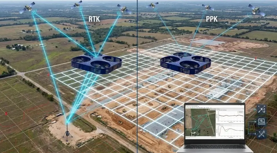
RTK and PPK are the two main correction methods used to close that gap. Real-Time Kinematic (RTK) applies corrections during the flight, while Post-Processed Kinematic (PPK) refines the raw data after the mission is complete.
Both approaches solve the same core issue: standard GNSS positioning alone is not accurate enough for professional mapping work.
This article explains why these systems matter, where they are commonly misused, and what a proper workflow actually looks like in the field. Whether you are planning a survey or delivering one, these details directly affect the quality and credibility of your results.
Why Positioning Accuracy Is the Foundation of Every Drone Survey
A standard drone GNSS receiver typically places the aircraft within a few meters of its true location. This is acceptable for video work or basic inspection photography, but it quickly becomes a limitation in technical applications.
In topographic mapping, volume calculations, and infrastructure monitoring, even small positional errors can significantly impact results and lead to incorrect conclusions.
Traditional surveying relied on physical control points and carefully adjusted ground networks. Drone mapping has sped up data collection, but it has not eliminated the need for geodetic accuracy.
The control still has to come from a reliable reference, and RTK and PPK are what allow modern drone workflows to achieve that level of precision.
Across Ireland and Europe, projects are increasingly required to meet formal accuracy standards set by engineers, planners, or regulatory bodies.
Delivering data that cannot be independently verified or that fails checkpoint validation creates risk for the surveying team and delays for the client. Positional accuracy is not optional — it is a professional requirement.
Seven Critical Mistakes in RTK and PPK Workflows
Mistake 1: Choosing the Wrong Correction Method for the Site
RTK performs well on open sites with strong connectivity or a clear link to a base station. However, in valleys, coastal areas, or remote terrain, the live correction signal can become unstable.
If the signal drops during flight, images may be recorded without reliable corrected positions, and the issue may only appear during processing.
PPK avoids this problem because it does not rely on a live connection. Instead, it uses logged GNSS data from both the drone and base station, which is corrected after the flight. In simple terms, if you cannot guarantee stable signal coverage for the entire mission, PPK is usually the safer option.
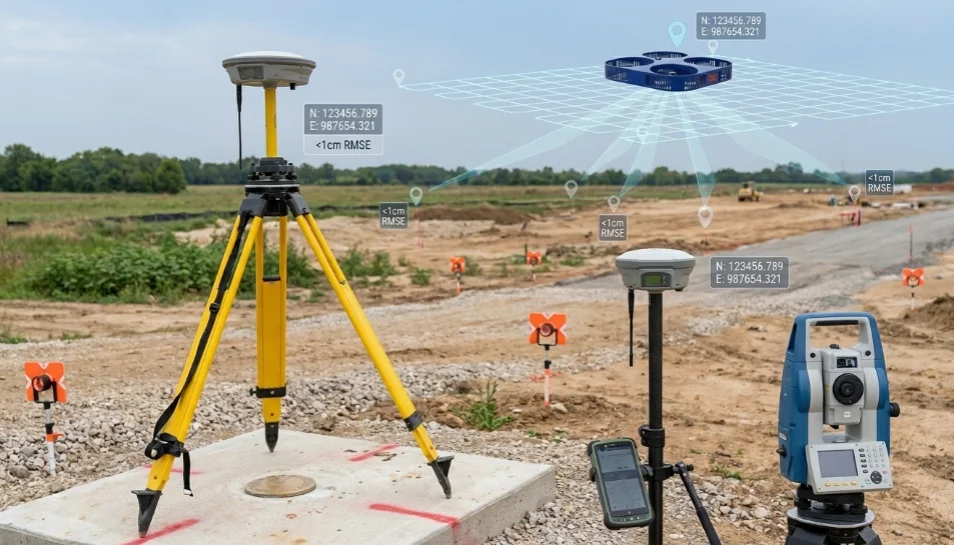
Mistake 2: Setting Up a Base Station Without a Verified Control Point
A base station is not just a temporary setup point — it is the geodetic foundation of the entire dataset. If its coordinates are incorrect, every image in the project inherits that error.
A common mistake is relying on an averaged autonomous position instead of a verified control point. This can introduce errors of 0.5 to 1.5 meters depending on conditions.
In Ireland, base station coordinates should reference the Irish Transverse Mercator (ITM) system and, where possible, tie into Ordnance Survey Ireland benchmarks. Skipping this step is one of the most costly mistakes in drone surveying.
Mistake 3: Confusing Ground Control Points With Check Points
These two are often mixed up, but they serve very different roles.
Ground Control Points (GCPs) are used during processing to align the model to the ground. Checkpoints are used after processing to independently verify accuracy.
A dataset processed only with GCPs but not validated with checkpoints has not been properly quality checked.
Checkpoints should be measured independently using a total station or GNSS rover. In professional surveys, three to five well-distributed checkpoints are standard. Without them, accuracy claims are assumptions, not verified results.
Mistake 4: Overlooking GNSS Constellation Coverage
Survey-grade drones track multiple satellite systems, including GPS, GLONASS, Galileo, and BeiDou.
More satellites improve positioning stability, fix speed, and reliability in partially obstructed environments.
Using a single-constellation receiver increases risk. Satellite geometry becomes weaker, and positional drift becomes more likely. Before any project, GNSS specifications should be confirmed in writing. Multi-constellation, multi-frequency support should be the baseline for any survey-grade work.
Mistake 5: Ignoring Camera and GNSS Time Synchronization
In PPK workflows, GNSS data and camera triggers must be precisely aligned.
If timestamps are not synchronized, images may be matched to slightly incorrect positions.
Even a small timing error of 50 milliseconds can introduce 25–50 cm of displacement at normal flight speeds. These errors are difficult to detect later, so synchronization should always be checked before and after the mission.
Mistake 6: Skipping the Coordinate Reference System Conversation
Every dataset exists within a coordinate reference system (CRS). This defines how spatial data aligns with the real world.
Using the wrong CRS can shift entire datasets when imported into GIS or engineering software.
This mistake often happens during delivery when default software settings are used without checking client requirements.
Always confirm the horizontal datum, vertical datum, and projection before any flight begins. These settings must also be clearly documented in the final report. Correct CRS handling is not an extra service — it is a core part of surveying.
Mistake 7: Treating Flight Planning as Separate From Accuracy Planning
RTK and PPK only solve positioning accuracy. They do not fix poor flight design.
Image overlap, flight altitude, and ground sampling distance (GSD) directly affect data quality.
For reliable mapping, 75–80% overlap is typically required. Complex terrain may require higher overlap or additional flight lines. If flight planning is incorrect, no level of post-processing can recover missing spatial detail.
What Success and Failure Look Like in the Field
A road infrastructure project in the Irish midlands illustrates how base station errors propagate. The survey team used PPK and flew a tight grid with strong overlap. The base station, however, was set up on an unverified point using averaged autonomous positioning. When the client’s engineers overlaid the orthomosaic against existing road centreline data, structures were displaced by approximately 0.7 meters.
Retracing the problem took two days. The base station coordinate was found to be 0.6 meters off in easting. The entire dataset had to be reprocessed from scratch after the corrected base station position was established through a proper static GNSS observation tied to a nearby Ordnance Survey benchmark. A single verified control point at the start would have prevented the delay entirely.
On the positive side, a long-running coastal monitoring program along the west of Ireland demonstrates what a disciplined workflow produces. Each seasonal survey uses the same base station monuments, deploys five checkpoints measured by a licensed land surveyor, and processes in ITM with Malin Head heights.
The vertical residuals across three years of data consistently fall within 4 centimeters, and the differences between the models from the two surveys are accepted by the environmental authority commissioning the work.
The visual outputs from that program, including color-mapped elevation change models and annotated orthomosaics, are regularly used in public planning submissions. That level of client confidence comes entirely from the accuracy discipline built into the workflow, not from the drone itself. Teams exploring how this standard applies to commercial projects can look at how drone services in Ireland are building these verification steps directly into standard deliverable packages.
A Field-Ready Checklist for RTK and PPK Projects
Before You Leave the Office
-
▸
Confirm the required horizontal, projection, and vertical datums in writing with the client. -
▸
Identify the base station occupation point and verify its coordinate against the national control network. -
▸
Plan flight parameters, including altitude, overlap, and GSD, to meet the stated accuracy specification. -
▸
Confirm the drone’s GNSS receiver supports multi-constellation, multi-frequency operation. -
▸
Plan checkpoint locations across the project area before mobilization.
On Site
-
▸
Precisely occupy the base station at the verified control point before powering on the receiver. -
▸
Begin logging base station GNSS data and allow sufficient warm-up time before the first flight. -
▸
Survey check point targets with a calibrated total station or independently verified GNSS rover. -
▸
Confirm fix status before takeoff for RTK missions and review the event log immediately after landing for PPK. -
▸
Log base station data for at least 10 minutes after the final flight lands.
Back at the Office
-
▸
Match the PPK correction files to the drone’s raw GNSS log and apply corrections before processing. -
▸
Run photogrammetric processing using corrected image positions. -
▸
Import independent checkpoint coordinates and compute residuals against the processed model. -
▸
Confirm all residuals fall within the stated accuracy tolerance before finalizing outputs. -
▸
Deliver outputs in the confirmed reference system with a written accuracy statement.
What These Technologies Still Cannot Do
RTK and PPK still depend on good GNSS conditions, clear sky visibility, and stable base station setups.
Dense urban areas, forests, and interference zones can still reduce accuracy.
Network RTK reduces the need for physical base stations but introduces dependency on mobile coverage.
Precise Point Positioning (PPP) is improving but is not yet standard for most production workflows.
Frequently Asked Questions
Accuracy Is Not an Add-On. It Is the Point.
RTK and PPK exist because modern industries need drone data they can trust.
What separates good results from poor ones is not the drone itself, but the discipline used in planning, field setup, and validation.
Verified control points, proper checkpoints, correct coordinate systems, and synchronized workflows are not advanced extras; they are basic professional requirements.
Teams that ignore them often end up reprocessing entire datasets and explaining avoidable errors to clients.
If you are commissioning drone surveys, always ask for checkpoint residuals and accuracy reports. If you are delivering them, build verification into the workflow from the start.
Because in the end, accuracy is decided long before the drone ever takes off.
Get Professional RTK and PPK Drone Surveys With Verified Accuracy
Accuracy is not optional in professional drone surveying. Our certified teams deploy verified base stations, independent checkpoints, and rigorous quality control on every project. We deliver results tied to national control networks with documented checkpoint residuals and accuracy reports. Whether you need topographic mapping, volumetric calculations, or infrastructure monitoring, we build verification into every workflow to ensure results you can depend on.